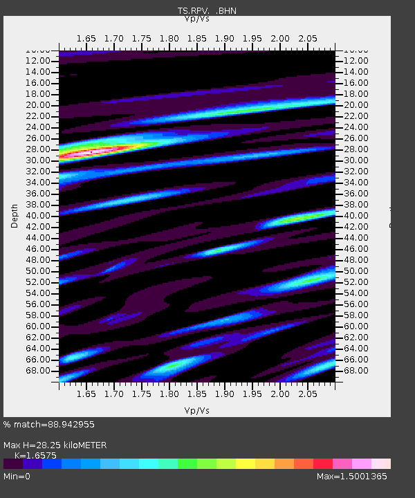
RPV Rancho Palos Verde California, USA - Earthquake Result Viewer
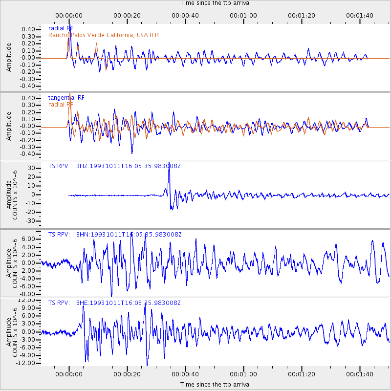
Earthquake location: Southeast Of Honshu, Japan
Earthquake latitude/longitude: 32.0/137.9
Earthquake time(UTC): 1993/10/11 (284) 15:54:22 GMT
Earthquake Depth: 365 km
Earthquake Magnitude: 6.5 MB, 6.8 UNKNOWN, 6.9 MW
Earthquake Catalog/Contributor: WHDF/NEIC
Network: TS TERRAscope (Southern California Seismic Network)
Station: RPV Rancho Palos Verde California, USA
Lat/Lon: 33.74 N/118.40 W
Elevation: 115 m
Distance: 82.9 deg
Az: 54.649 deg
Baz: 303.732 deg
Ray Param: 0.04558971
Estimated Moho Depth: 28.25 km
Estimated Crust Vp/Vs: 1.66
Assumed Crust Vp: 6.048 km/s
Estimated Crust Vs: 3.649 km/s
Estimated Crust Poisson's Ratio: 0.21
Radial Match: 88.942955 %
Radial Bump: 400
Transverse Match: 87.55997 %
Transverse Bump: 400
SOD ConfigId: 16938
Insert Time: 2010-02-26 14:44:51.860 +0000
GWidth: 2.5
Max Bumps: 400
Tol: 0.001

Signal To Noise

ChannelStoNSTALTA
TS:RPV: :BHN:19931011T16:05:35.983008Z3.4744491.538267E-64.42737E-7
TS:RPV: :BHE:19931011T16:05:35.983008Z6.89081572.4122696E-63.5007025E-7
TS:RPV: :BHZ:19931011T16:05:35.983008Z39.2504461.0205008E-52.5999722E-7
Arrivals
Ps3.1 SECOND
PpPs12 SECOND
PsPs/PpSs15 SECOND