You are here: Home > Network List > AU - Australian Seismological Centre Stations List
> Station PSAB2 Pilbara Seismic Array Element B2 > Earthquake Result Viewer
PSAB2 Pilbara Seismic Array Element B2 - Earthquake Result Viewer
| Earthquake location: |
Vanuatu Islands |
| Earthquake latitude/longitude: |
-14.6/167.4 |
| Earthquake time(UTC): |
2017/05/09 (129) 13:52:10 GMT |
| Earthquake Depth: |
169 km |
| Earthquake Magnitude: |
6.8 mww |
| Earthquake Catalog/Contributor: |
NEIC PDE/us |
|
| Network: |
AU Australian Seismological Centre |
| Station: |
PSAB2 Pilbara Seismic Array Element B2 |
| Lat/Lon: |
21.55 S/119.86 E |
| Elevation: |
302 m |
|
| Distance: |
45.6 deg |
| Az: |
254.053 deg |
| Baz: |
89.543 deg |
| Ray Param: |
0.07058154 |
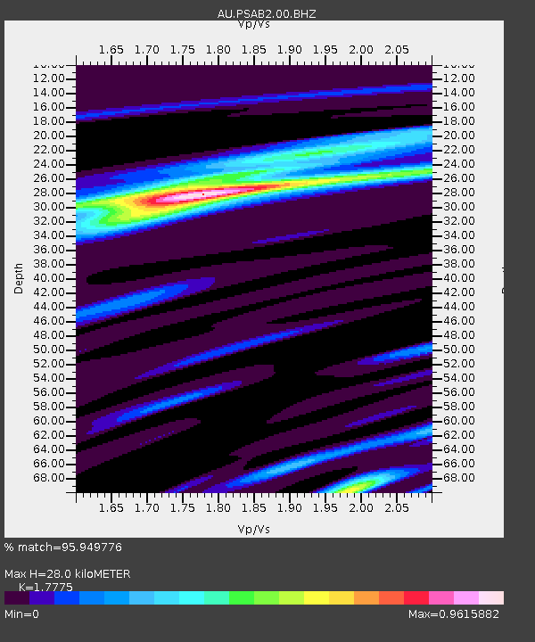
| Estimated Moho Depth: |
28.0 km |
| Estimated Crust Vp/Vs: |
1.78 |
| Assumed Crust Vp: |
6.464 km/s |
| Estimated Crust Vs: |
3.636 km/s |
| Estimated Crust Poisson's Ratio: |
0.27 |
|
| Radial Match: |
95.949776 % |
| Radial Bump: |
223 |
| Transverse Match: |
78.342186 % |
| Transverse Bump: |
342 |
| SOD ConfigId: |
2028011 |
| Insert Time: |
2017-05-23 13:52:49.672 +0000 |
| GWidth: |
2.5 |
| Max Bumps: |
400 |
| Tol: |
0.001 |
|

Signal To Noise
| Channel | StoN | STA | LTA |
| AU:PSAB2:00:BHZ:20170509T13:59:43.318987Z | 43.27678 | 1.8184594E-5 | 4.2019286E-7 |
| AU:PSAB2:00:BH1:20170509T13:59:43.318987Z | 21.096148 | 7.4736618E-6 | 3.5426666E-7 |
| AU:PSAB2:00:BH2:20170509T13:59:43.318987Z | 18.230331 | 7.4140826E-6 | 4.066894E-7 |
| Arrivals |
| Ps | 3.6 SECOND |
| PpPs | 11 SECOND |
| PsPs/PpSs | 15 SECOND |


