You are here: Home > Network List > TA - USArray Transportable Network (new EarthScope stations) Stations List
> Station D23K Nanushuk River, AK USA > Earthquake Result Viewer
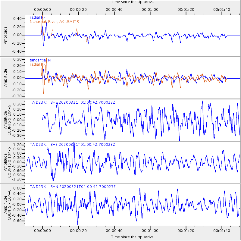
D23K Nanushuk River, AK USA - Earthquake Result Viewer
*The percent match for this event was below the threshold and hence no stack was calculated.
| Earthquake location: |
Greece-Albania Border Region |
| Earthquake latitude/longitude: |
39.4/20.6 |
| Earthquake time(UTC): |
2020/03/21 (081) 00:49:51 GMT |
| Earthquake Depth: |
10 km |
| Earthquake Magnitude: |
5.7 Mww |
| Earthquake Catalog/Contributor: |
NEIC PDE/us |
|
| Network: |
TA USArray Transportable Network (new EarthScope stations) |
| Station: |
D23K Nanushuk River, AK USA |
| Lat/Lon: |
68.97 N/150.68 W |
| Elevation: |
406 m |
|
| Distance: |
71.8 deg |
| Az: |
356.709 deg |
| Baz: |
7.079 deg |
| Ray Param: |
$rayparam |
*The percent match for this event was below the threshold and hence was not used in the summary stack. |
|
| Radial Match: |
73.5047 % |
| Radial Bump: |
400 |
| Transverse Match: |
66.001785 % |
| Transverse Bump: |
400 |
| SOD ConfigId: |
20906531 |
| Insert Time: |
2020-04-08 13:40:09.785 +0000 |
| GWidth: |
2.5 |
| Max Bumps: |
400 |
| Tol: |
0.001 |
|
Signal To Noise
| Channel | StoN | STA | LTA |
| TA:D23K: :BHZ:20200321T01:00:42.700023Z | 2.22936 | 4.9844755E-7 | 2.2358323E-7 |
| TA:D23K: :BHN:20200321T01:00:42.700023Z | 1.3248084 | 2.669179E-7 | 2.0147661E-7 |
| TA:D23K: :BHE:20200321T01:00:42.700023Z | 1.2203803 | 1.6017621E-7 | 1.3125107E-7 |
| Arrivals |
| Ps | |
| PpPs | |
| PsPs/PpSs | |


