You are here: Home > Network List > TA - USArray Transportable Network (new EarthScope stations) Stations List
> Station E18K Tukpahlearik Creek, AK, USA > Earthquake Result Viewer
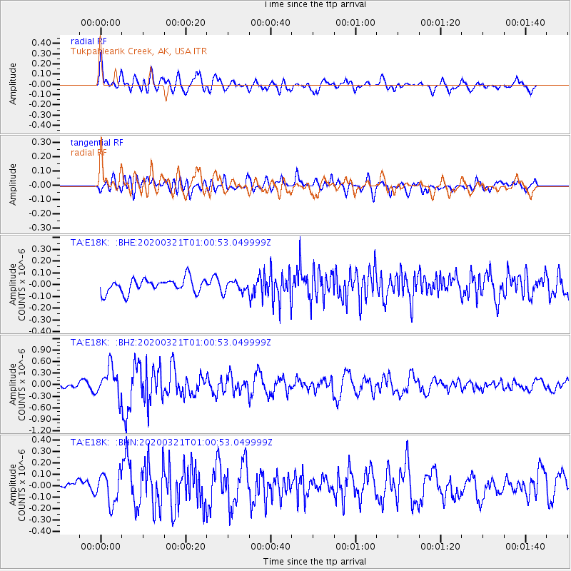
E18K Tukpahlearik Creek, AK, USA - Earthquake Result Viewer
*The percent match for this event was below the threshold and hence no stack was calculated.
| Earthquake location: |
Greece-Albania Border Region |
| Earthquake latitude/longitude: |
39.4/20.6 |
| Earthquake time(UTC): |
2020/03/21 (081) 00:49:51 GMT |
| Earthquake Depth: |
10 km |
| Earthquake Magnitude: |
5.7 Mww |
| Earthquake Catalog/Contributor: |
NEIC PDE/us |
|
| Network: |
TA USArray Transportable Network (new EarthScope stations) |
| Station: |
E18K Tukpahlearik Creek, AK, USA |
| Lat/Lon: |
67.42 N/160.60 W |
| Elevation: |
297 m |
|
| Distance: |
73.5 deg |
| Az: |
0.498 deg |
| Baz: |
359.001 deg |
| Ray Param: |
$rayparam |
*The percent match for this event was below the threshold and hence was not used in the summary stack. |
|
| Radial Match: |
79.96683 % |
| Radial Bump: |
400 |
| Transverse Match: |
69.326324 % |
| Transverse Bump: |
400 |
| SOD ConfigId: |
20906531 |
| Insert Time: |
2020-04-08 13:40:16.432 +0000 |
| GWidth: |
2.5 |
| Max Bumps: |
400 |
| Tol: |
0.001 |
|
Signal To Noise
| Channel | StoN | STA | LTA |
| TA:E18K: :BHZ:20200321T01:00:53.049999Z | 3.9794955 | 3.8774593E-7 | 9.743595E-8 |
| TA:E18K: :BHN:20200321T01:00:53.049999Z | 2.3771305 | 1.3470658E-7 | 5.6667723E-8 |
| TA:E18K: :BHE:20200321T01:00:53.049999Z | 0.7321107 | 4.3596316E-8 | 5.9548803E-8 |
| Arrivals |
| Ps | |
| PpPs | |
| PsPs/PpSs | |


