You are here: Home > Network List > TA - USArray Transportable Network (new EarthScope stations) Stations List
> Station M24K Tolsona, Glennallen, AK, USA > Earthquake Result Viewer
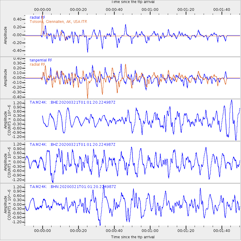
M24K Tolsona, Glennallen, AK, USA - Earthquake Result Viewer
*The percent match for this event was below the threshold and hence no stack was calculated.
| Earthquake location: |
Greece-Albania Border Region |
| Earthquake latitude/longitude: |
39.4/20.6 |
| Earthquake time(UTC): |
2020/03/21 (081) 00:49:51 GMT |
| Earthquake Depth: |
10 km |
| Earthquake Magnitude: |
5.7 Mww |
| Earthquake Catalog/Contributor: |
NEIC PDE/us |
|
| Network: |
TA USArray Transportable Network (new EarthScope stations) |
| Station: |
M24K Tolsona, Glennallen, AK, USA |
| Lat/Lon: |
62.11 N/146.18 W |
| Elevation: |
908 m |
|
| Distance: |
78.3 deg |
| Az: |
353.708 deg |
| Baz: |
10.407 deg |
| Ray Param: |
$rayparam |
*The percent match for this event was below the threshold and hence was not used in the summary stack. |
|
| Radial Match: |
64.323265 % |
| Radial Bump: |
400 |
| Transverse Match: |
49.49821 % |
| Transverse Bump: |
400 |
| SOD ConfigId: |
20906531 |
| Insert Time: |
2020-04-08 13:41:51.294 +0000 |
| GWidth: |
2.5 |
| Max Bumps: |
400 |
| Tol: |
0.001 |
|
Signal To Noise
| Channel | StoN | STA | LTA |
| TA:M24K: :BHZ:20200321T01:01:20.224987Z | 1.8863018 | 5.33816E-7 | 2.8299607E-7 |
| TA:M24K: :BHN:20200321T01:01:20.224987Z | 1.0753275 | 2.2859845E-7 | 2.1258496E-7 |
| TA:M24K: :BHE:20200321T01:01:20.224987Z | 0.6651479 | 2.7374134E-7 | 4.115496E-7 |
| Arrivals |
| Ps | |
| PpPs | |
| PsPs/PpSs | |


