You are here: Home > Network List > G - GEOSCOPE Stations List
> Station DRV Dumont d'Urville, Terre Adelie (Antartica) > Earthquake Result Viewer
DRV Dumont d'Urville, Terre Adelie (Antartica) - Earthquake Result Viewer
| Earthquake location: |
Vanuatu Islands |
| Earthquake latitude/longitude: |
-14.6/167.4 |
| Earthquake time(UTC): |
2017/05/09 (129) 13:52:10 GMT |
| Earthquake Depth: |
169 km |
| Earthquake Magnitude: |
6.8 mww |
| Earthquake Catalog/Contributor: |
NEIC PDE/us |
|
| Network: |
G GEOSCOPE |
| Station: |
DRV Dumont d'Urville, Terre Adelie (Antartica) |
| Lat/Lon: |
66.67 S/140.01 E |
| Elevation: |
40 m |
|
| Distance: |
55.1 deg |
| Az: |
192.901 deg |
| Baz: |
32.863 deg |
| Ray Param: |
0.06445501 |
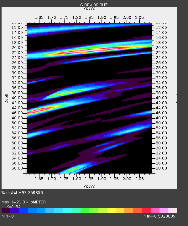
| Estimated Moho Depth: |
21.0 km |
| Estimated Crust Vp/Vs: |
1.84 |
| Assumed Crust Vp: |
6.39 km/s |
| Estimated Crust Vs: |
3.473 km/s |
| Estimated Crust Poisson's Ratio: |
0.29 |
|
| Radial Match: |
97.359856 % |
| Radial Bump: |
273 |
| Transverse Match: |
88.1765 % |
| Transverse Bump: |
400 |
| SOD ConfigId: |
2028011 |
| Insert Time: |
2017-05-23 13:53:31.882 +0000 |
| GWidth: |
2.5 |
| Max Bumps: |
400 |
| Tol: |
0.001 |
|

Signal To Noise
| Channel | StoN | STA | LTA |
| G:DRV:00:BHZ:20170509T14:00:54.750017Z | 64.92529 | 2.7478964E-5 | 4.2323973E-7 |
| G:DRV:00:BHN:20170509T14:00:54.750017Z | 25.810455 | 1.2766857E-5 | 4.94639E-7 |
| G:DRV:00:BHE:20170509T14:00:54.750017Z | 18.974642 | 8.408424E-6 | 4.4314007E-7 |
| Arrivals |
| Ps | 2.9 SECOND |
| PpPs | 8.9 SECOND |
| PsPs/PpSs | 12 SECOND |


