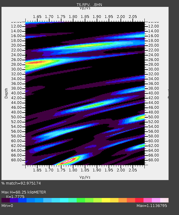
RPV Rancho Palos Verde California, USA - Earthquake Result Viewer
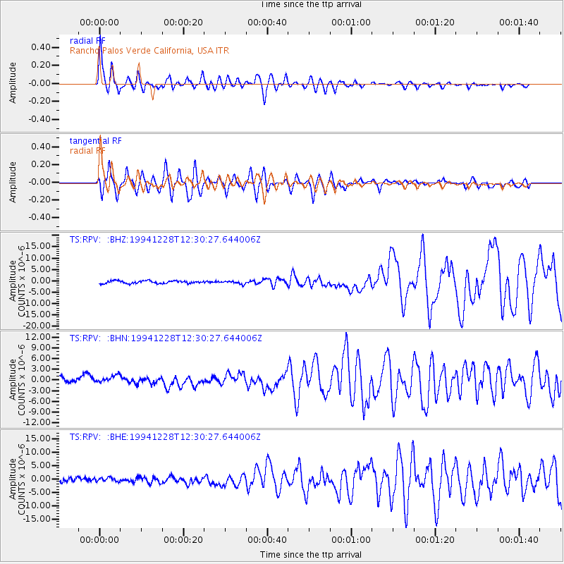
Earthquake location: Off East Coast Of Honshu, Japan
Earthquake latitude/longitude: 40.5/143.5
Earthquake time(UTC): 1994/12/28 (362) 12:19:23 GMT
Earthquake Depth: 33 km
Earthquake Magnitude: 6.4 MB, 7.5 MS, 7.2 UNKNOWN, 7.7 MW
Earthquake Catalog/Contributor: WHDF/NEIC
Network: TS TERRAscope (Southern California Seismic Network)
Station: RPV Rancho Palos Verde California, USA
Lat/Lon: 33.74 N/118.40 W
Elevation: 115 m
Distance: 74.5 deg
Az: 58.889 deg
Baz: 308.363 deg
Ray Param: 0.052261144
Estimated Moho Depth: 68.25 km
Estimated Crust Vp/Vs: 1.78
Assumed Crust Vp: 6.048 km/s
Estimated Crust Vs: 3.402 km/s
Estimated Crust Poisson's Ratio: 0.27
Radial Match: 92.975174 %
Radial Bump: 400
Transverse Match: 88.32821 %
Transverse Bump: 400
SOD ConfigId: 16938
Insert Time: 2010-02-26 14:44:57.749 +0000
GWidth: 2.5
Max Bumps: 400
Tol: 0.001

Signal To Noise

ChannelStoNSTALTA
TS:RPV: :BHN:19941228T12:30:27.644006Z1.21245471.6361929E-61.3494879E-6
TS:RPV: :BHE:19941228T12:30:27.644006Z0.973010668.001714E-78.2236653E-7
TS:RPV: :BHZ:19941228T12:30:27.644006Z1.12375036.663851E-75.93001E-7
Arrivals
Ps9.0 SECOND
PpPs30 SECOND
PsPs/PpSs39 SECOND