You are here: Home > Network List > US - United States National Seismic Network Stations List
> Station MIAR Mount Ida, Arkansas, USA > Earthquake Result Viewer
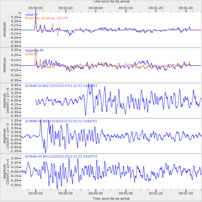
MIAR Mount Ida, Arkansas, USA - Earthquake Result Viewer
*The percent match for this event was below the threshold and hence no stack was calculated.
| Earthquake location: |
Greece-Albania Border Region |
| Earthquake latitude/longitude: |
39.4/20.6 |
| Earthquake time(UTC): |
2020/03/21 (081) 00:49:51 GMT |
| Earthquake Depth: |
10 km |
| Earthquake Magnitude: |
5.7 Mww |
| Earthquake Catalog/Contributor: |
NEIC PDE/us |
|
| Network: |
US United States National Seismic Network |
| Station: |
MIAR Mount Ida, Arkansas, USA |
| Lat/Lon: |
34.55 N/93.58 W |
| Elevation: |
207 m |
|
| Distance: |
84.6 deg |
| Az: |
310.868 deg |
| Baz: |
45.243 deg |
| Ray Param: |
$rayparam |
*The percent match for this event was below the threshold and hence was not used in the summary stack. |
|
| Radial Match: |
66.89921 % |
| Radial Bump: |
400 |
| Transverse Match: |
52.299595 % |
| Transverse Bump: |
400 |
| SOD ConfigId: |
20906531 |
| Insert Time: |
2020-04-08 13:45:11.806 +0000 |
| GWidth: |
2.5 |
| Max Bumps: |
400 |
| Tol: |
0.001 |
|
Signal To Noise
| Channel | StoN | STA | LTA |
| US:MIAR:00:BHZ:20200321T01:01:53.399975Z | 6.548319 | 4.3523406E-7 | 6.6465006E-8 |
| US:MIAR:00:BH1:20200321T01:01:53.399975Z | 0.8444175 | 6.970359E-8 | 8.254636E-8 |
| US:MIAR:00:BH2:20200321T01:01:53.399975Z | 3.1633024 | 1.7148749E-7 | 5.4211533E-8 |
| Arrivals |
| Ps | |
| PpPs | |
| PsPs/PpSs | |


