You are here: Home > Network List > US - United States National Seismic Network Stations List
> Station MNTX Cornudas Mountains, Texas, USA > Earthquake Result Viewer
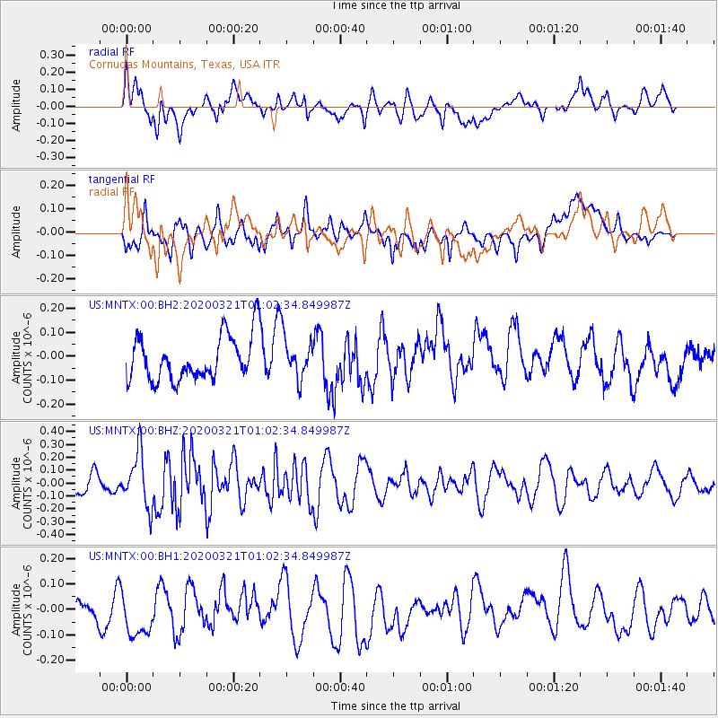
MNTX Cornudas Mountains, Texas, USA - Earthquake Result Viewer
*The percent match for this event was below the threshold and hence no stack was calculated.
| Earthquake location: |
Greece-Albania Border Region |
| Earthquake latitude/longitude: |
39.4/20.6 |
| Earthquake time(UTC): |
2020/03/21 (081) 00:49:51 GMT |
| Earthquake Depth: |
10 km |
| Earthquake Magnitude: |
5.7 Mww |
| Earthquake Catalog/Contributor: |
NEIC PDE/us |
|
| Network: |
US United States National Seismic Network |
| Station: |
MNTX Cornudas Mountains, Texas, USA |
| Lat/Lon: |
31.70 N/105.38 W |
| Elevation: |
404 m |
|
| Distance: |
93.3 deg |
| Az: |
316.319 deg |
| Baz: |
38.904 deg |
| Ray Param: |
$rayparam |
*The percent match for this event was below the threshold and hence was not used in the summary stack. |
|
| Radial Match: |
48.09507 % |
| Radial Bump: |
400 |
| Transverse Match: |
56.345245 % |
| Transverse Bump: |
400 |
| SOD ConfigId: |
20906531 |
| Insert Time: |
2020-04-08 13:45:14.567 +0000 |
| GWidth: |
2.5 |
| Max Bumps: |
400 |
| Tol: |
0.001 |
|
Signal To Noise
| Channel | StoN | STA | LTA |
| US:MNTX:00:BHZ:20200321T01:02:34.849987Z | 2.827815 | 2.1134456E-7 | 7.4737756E-8 |
| US:MNTX:00:BH1:20200321T01:02:34.849987Z | 2.068497 | 9.3351794E-8 | 4.513025E-8 |
| US:MNTX:00:BH2:20200321T01:02:34.849987Z | 0.89964366 | 8.332941E-8 | 9.262491E-8 |
| Arrivals |
| Ps | |
| PpPs | |
| PsPs/PpSs | |


