You are here: Home > Network List > TS - TERRAscope (Southern California Seismic Network) Stations List
> Station RPV Rancho Palos Verde California, USA > Earthquake Result Viewer
RPV Rancho Palos Verde California, USA - Earthquake Result Viewer
| Earthquake location: |
Vanuatu Islands |
| Earthquake latitude/longitude: |
-17.8/167.6 |
| Earthquake time(UTC): |
1994/10/01 (274) 16:35:22 GMT |
| Earthquake Depth: |
33 km |
| Earthquake Magnitude: |
5.7 MB, 6.5 MS, 6.5 UNKNOWN, 6.5 MW |
| Earthquake Catalog/Contributor: |
WHDF/NEIC |
|
| Network: |
TS TERRAscope (Southern California Seismic Network) |
| Station: |
RPV Rancho Palos Verde California, USA |
| Lat/Lon: |
33.74 N/118.40 W |
| Elevation: |
115 m |
|
| Distance: |
87.0 deg |
| Az: |
53.311 deg |
| Baz: |
246.509 deg |
| Ray Param: |
0.04357676 |
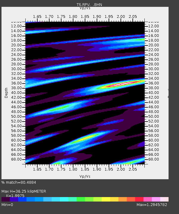
| Estimated Moho Depth: |
36.25 km |
| Estimated Crust Vp/Vs: |
2.00 |
| Assumed Crust Vp: |
6.048 km/s |
| Estimated Crust Vs: |
3.028 km/s |
| Estimated Crust Poisson's Ratio: |
0.33 |
|
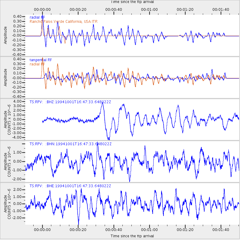
| Radial Match: |
80.4884 % |
| Radial Bump: |
400 |
| Transverse Match: |
69.51727 % |
| Transverse Bump: |
400 |
| SOD ConfigId: |
17000 |
| Insert Time: |
2010-02-26 14:44:59.024 +0000 |
| GWidth: |
2.5 |
| Max Bumps: |
400 |
| Tol: |
0.001 |
|
Signal To Noise
| Channel | StoN | STA | LTA |
| TS:RPV: :BHN:19941001T16:47:33.648022Z | 1.2818538 | 5.536593E-7 | 4.3192074E-7 |
| TS:RPV: :BHE:19941001T16:47:33.648022Z | 1.9165605 | 7.766874E-7 | 4.0525063E-7 |
| TS:RPV: :BHZ:19941001T16:47:33.648022Z | 6.447744 | 1.926391E-6 | 2.9876978E-7 |
| Arrivals |
| Ps | 6.1 SECOND |
| PpPs | 18 SECOND |
| PsPs/PpSs | 24 SECOND |


