You are here: Home > Network List > WY - Yellowstone Wyoming Seismic Network Stations List
> Station YHH Holmes Hill, YNP, WY, USA > Earthquake Result Viewer
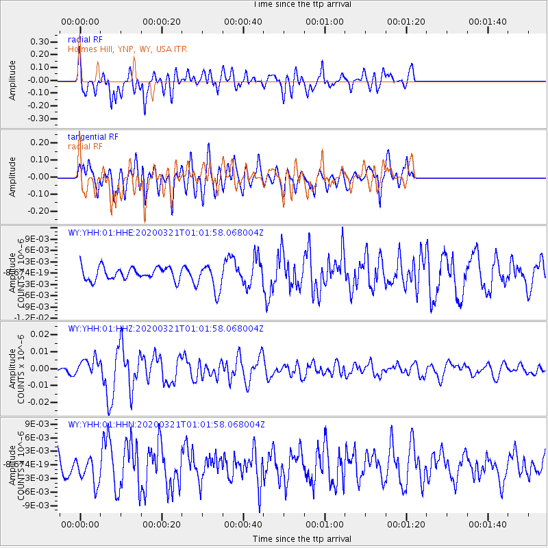
YHH Holmes Hill, YNP, WY, USA - Earthquake Result Viewer
*The percent match for this event was below the threshold and hence no stack was calculated.
| Earthquake location: |
Greece-Albania Border Region |
| Earthquake latitude/longitude: |
39.4/20.6 |
| Earthquake time(UTC): |
2020/03/21 (081) 00:49:51 GMT |
| Earthquake Depth: |
10 km |
| Earthquake Magnitude: |
5.7 Mww |
| Earthquake Catalog/Contributor: |
NEIC PDE/us |
|
| Network: |
WY Yellowstone Wyoming Seismic Network |
| Station: |
YHH Holmes Hill, YNP, WY, USA |
| Lat/Lon: |
44.79 N/110.85 W |
| Elevation: |
2717 m |
|
| Distance: |
85.5 deg |
| Az: |
327.651 deg |
| Baz: |
35.622 deg |
| Ray Param: |
$rayparam |
*The percent match for this event was below the threshold and hence was not used in the summary stack. |
|
| Radial Match: |
70.74436 % |
| Radial Bump: |
400 |
| Transverse Match: |
81.47046 % |
| Transverse Bump: |
400 |
| SOD ConfigId: |
20906531 |
| Insert Time: |
2020-04-08 13:47:38.682 +0000 |
| GWidth: |
2.5 |
| Max Bumps: |
400 |
| Tol: |
0.001 |
|
Signal To Noise
| Channel | StoN | STA | LTA |
| WY:YHH:01:HHZ:20200321T01:01:58.068004Z | 2.9299936 | 5.2118194E-9 | 1.7787819E-9 |
| WY:YHH:01:HHN:20200321T01:01:58.068004Z | 1.4698855 | 3.1468679E-9 | 2.1408932E-9 |
| WY:YHH:01:HHE:20200321T01:01:58.068004Z | 2.2045493 | 3.6597207E-9 | 1.6600766E-9 |
| Arrivals |
| Ps | |
| PpPs | |
| PsPs/PpSs | |


