You are here: Home > Network List > IU - Global Seismograph Network (GSN - IRIS/USGS) Stations List
> Station NWAO Narrogin, Australia > Earthquake Result Viewer
NWAO Narrogin, Australia - Earthquake Result Viewer
| Earthquake location: |
Vanuatu Islands |
| Earthquake latitude/longitude: |
-14.6/167.4 |
| Earthquake time(UTC): |
2017/05/09 (129) 13:52:10 GMT |
| Earthquake Depth: |
169 km |
| Earthquake Magnitude: |
6.8 mww |
| Earthquake Catalog/Contributor: |
NEIC PDE/us |
|
| Network: |
IU Global Seismograph Network (GSN - IRIS/USGS) |
| Station: |
NWAO Narrogin, Australia |
| Lat/Lon: |
32.93 S/117.24 E |
| Elevation: |
380 m |
|
| Distance: |
48.9 deg |
| Az: |
238.942 deg |
| Baz: |
80.445 deg |
| Ray Param: |
0.06844622 |
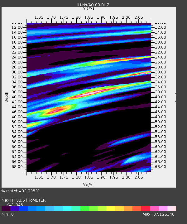
| Estimated Moho Depth: |
38.5 km |
| Estimated Crust Vp/Vs: |
1.85 |
| Assumed Crust Vp: |
6.419 km/s |
| Estimated Crust Vs: |
3.479 km/s |
| Estimated Crust Poisson's Ratio: |
0.29 |
|
| Radial Match: |
92.93531 % |
| Radial Bump: |
194 |
| Transverse Match: |
75.30058 % |
| Transverse Bump: |
352 |
| SOD ConfigId: |
2028011 |
| Insert Time: |
2017-05-23 13:54:26.957 +0000 |
| GWidth: |
2.5 |
| Max Bumps: |
400 |
| Tol: |
0.001 |
|
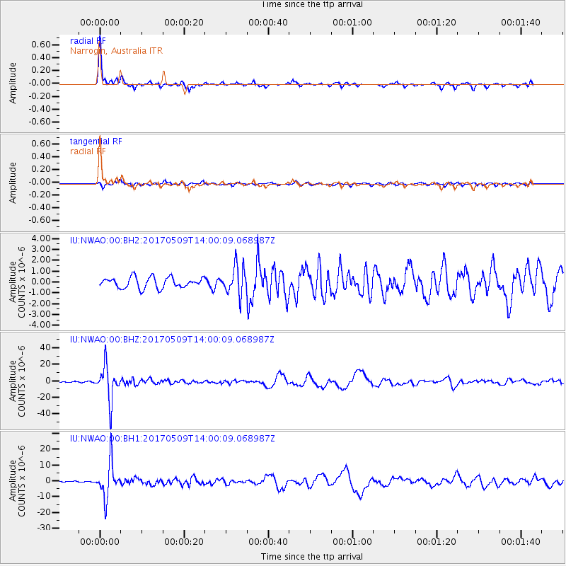
Signal To Noise
| Channel | StoN | STA | LTA |
| IU:NWAO:00:BHZ:20170509T14:00:09.068987Z | 35.14525 | 2.0825184E-5 | 5.925462E-7 |
| IU:NWAO:00:BH1:20170509T14:00:09.068987Z | 24.52082 | 1.1095647E-5 | 4.52499E-7 |
| IU:NWAO:00:BH2:20170509T14:00:09.068987Z | 2.6662266 | 1.3102044E-6 | 4.914078E-7 |
| Arrivals |
| Ps | 5.4 SECOND |
| PpPs | 16 SECOND |
| PsPs/PpSs | 21 SECOND |


