You are here: Home > Network List > TS - TERRAscope (Southern California Seismic Network) Stations List
> Station RPV Rancho Palos Verde California, USA > Earthquake Result Viewer
RPV Rancho Palos Verde California, USA - Earthquake Result Viewer
| Earthquake location: |
South Of Fiji Islands |
| Earthquake latitude/longitude: |
-25.8/179.3 |
| Earthquake time(UTC): |
1994/10/27 (300) 22:20:31 GMT |
| Earthquake Depth: |
549 km |
| Earthquake Magnitude: |
5.9 MB, 6.8 UNKNOWN, 6.7 MW |
| Earthquake Catalog/Contributor: |
WHDF/NEIC |
|
| Network: |
TS TERRAscope (Southern California Seismic Network) |
| Station: |
RPV Rancho Palos Verde California, USA |
| Lat/Lon: |
33.74 N/118.40 W |
| Elevation: |
115 m |
|
| Distance: |
83.7 deg |
| Az: |
47.899 deg |
| Baz: |
233.394 deg |
| Ray Param: |
0.044436354 |
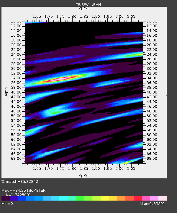
| Estimated Moho Depth: |
34.25 km |
| Estimated Crust Vp/Vs: |
1.74 |
| Assumed Crust Vp: |
6.048 km/s |
| Estimated Crust Vs: |
3.471 km/s |
| Estimated Crust Poisson's Ratio: |
0.25 |
|
| Radial Match: |
85.82842 % |
| Radial Bump: |
400 |
| Transverse Match: |
76.346 % |
| Transverse Bump: |
400 |
| SOD ConfigId: |
17000 |
| Insert Time: |
2010-02-26 14:45:02.872 +0000 |
| GWidth: |
2.5 |
| Max Bumps: |
400 |
| Tol: |
0.001 |
|
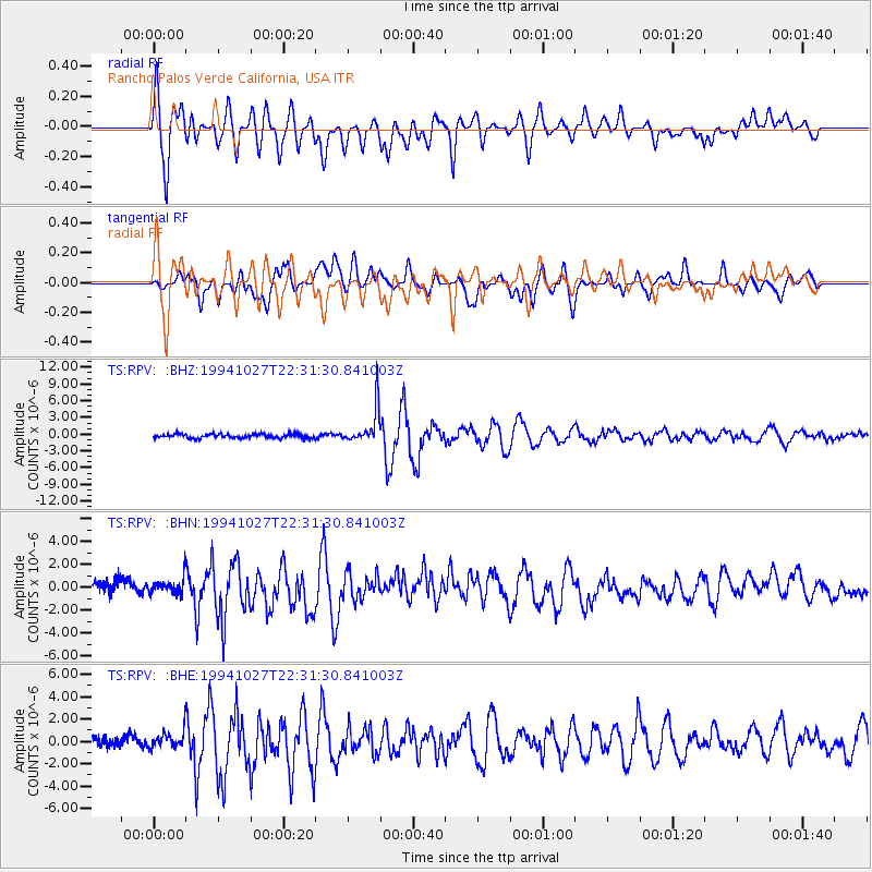
Signal To Noise
| Channel | StoN | STA | LTA |
| TS:RPV: :BHN:19941027T22:31:30.841003Z | 1.1801178 | 6.8931473E-7 | 5.841067E-7 |
| TS:RPV: :BHE:19941027T22:31:30.841003Z | 1.6244857 | 7.096341E-7 | 4.3683616E-7 |
| TS:RPV: :BHZ:19941027T22:31:30.841003Z | 8.978517 | 3.3276722E-6 | 3.7062605E-7 |
| Arrivals |
| Ps | 4.3 SECOND |
| PpPs | 15 SECOND |
| PsPs/PpSs | 19 SECOND |


