You are here: Home > Network List > TS - TERRAscope (Southern California Seismic Network) Stations List
> Station RPV Rancho Palos Verde California, USA > Earthquake Result Viewer
RPV Rancho Palos Verde California, USA - Earthquake Result Viewer
| Earthquake location: |
Solomon Islands |
| Earthquake latitude/longitude: |
-5.8/154.2 |
| Earthquake time(UTC): |
1995/08/16 (228) 10:27:26 GMT |
| Earthquake Depth: |
16 km |
| Earthquake Magnitude: |
6.4 MB, 7.8 MS, 7.8 UNKNOWN, 7.8 MW |
| Earthquake Catalog/Contributor: |
WHDF/NEIC |
|
| Network: |
TS TERRAscope (Southern California Seismic Network) |
| Station: |
RPV Rancho Palos Verde California, USA |
| Lat/Lon: |
33.74 N/118.40 W |
| Elevation: |
115 m |
|
| Distance: |
91.0 deg |
| Az: |
56.357 deg |
| Baz: |
263.748 deg |
| Ray Param: |
0.041631076 |
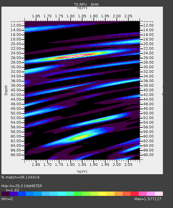
| Estimated Moho Depth: |
25.0 km |
| Estimated Crust Vp/Vs: |
1.82 |
| Assumed Crust Vp: |
6.048 km/s |
| Estimated Crust Vs: |
3.323 km/s |
| Estimated Crust Poisson's Ratio: |
0.28 |
|
| Radial Match: |
89.104416 % |
| Radial Bump: |
400 |
| Transverse Match: |
86.64971 % |
| Transverse Bump: |
400 |
| SOD ConfigId: |
6273 |
| Insert Time: |
2010-02-26 14:45:05.085 +0000 |
| GWidth: |
2.5 |
| Max Bumps: |
400 |
| Tol: |
0.001 |
|
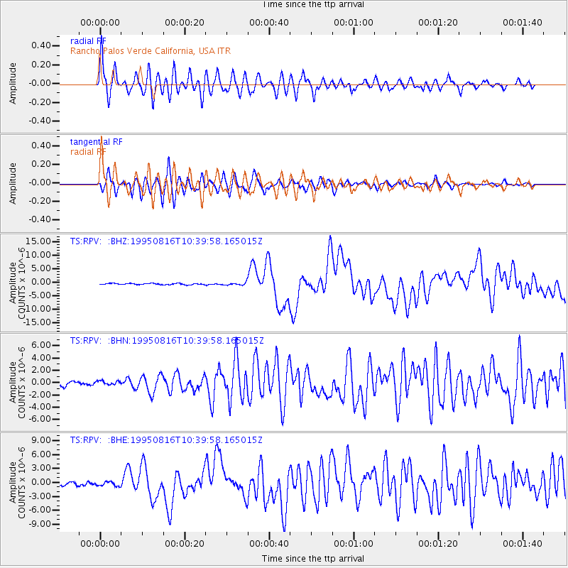
Signal To Noise
| Channel | StoN | STA | LTA |
| TS:RPV: :BHN:19950816T10:39:58.165015Z | 0.6819855 | 3.2148264E-7 | 4.7139218E-7 |
| TS:RPV: :BHE:19950816T10:39:58.165015Z | 1.5770435 | 4.820463E-7 | 3.0566454E-7 |
| TS:RPV: :BHZ:19950816T10:39:58.165015Z | 2.1302586 | 4.85946E-7 | 2.2811595E-7 |
| Arrivals |
| Ps | 3.5 SECOND |
| PpPs | 11 SECOND |
| PsPs/PpSs | 15 SECOND |


