You are here: Home > Network List > IU - Global Seismograph Network (GSN - IRIS/USGS) Stations List
> Station XMAS Kiritimati Island, Republic of Kiribati > Earthquake Result Viewer
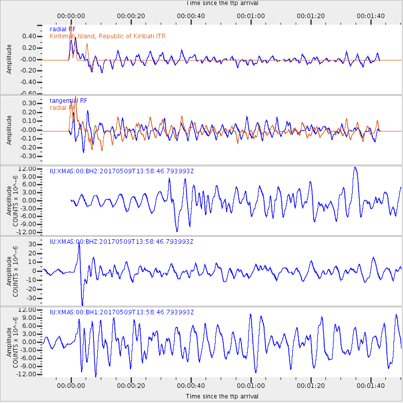
XMAS Kiritimati Island, Republic of Kiribati - Earthquake Result Viewer
*The percent match for this event was below the threshold and hence no stack was calculated.
| Earthquake location: |
Vanuatu Islands |
| Earthquake latitude/longitude: |
-14.6/167.4 |
| Earthquake time(UTC): |
2017/05/09 (129) 13:52:10 GMT |
| Earthquake Depth: |
169 km |
| Earthquake Magnitude: |
6.8 mww |
| Earthquake Catalog/Contributor: |
NEIC PDE/us |
|
| Network: |
IU Global Seismograph Network (GSN - IRIS/USGS) |
| Station: |
XMAS Kiritimati Island, Republic of Kiribati |
| Lat/Lon: |
2.04 N/157.45 W |
| Elevation: |
20 m |
|
| Distance: |
38.6 deg |
| Az: |
67.467 deg |
| Baz: |
243.48 deg |
| Ray Param: |
$rayparam |
*The percent match for this event was below the threshold and hence was not used in the summary stack. |
|
| Radial Match: |
69.92959 % |
| Radial Bump: |
400 |
| Transverse Match: |
58.36939 % |
| Transverse Bump: |
400 |
| SOD ConfigId: |
2028011 |
| Insert Time: |
2017-05-23 13:54:47.920 +0000 |
| GWidth: |
2.5 |
| Max Bumps: |
400 |
| Tol: |
0.001 |
|
Signal To Noise
| Channel | StoN | STA | LTA |
| IU:XMAS:00:BHZ:20170509T13:58:46.793993Z | 7.2236347 | 1.6154867E-5 | 2.2363904E-6 |
| IU:XMAS:00:BH1:20170509T13:58:46.793993Z | 2.710276 | 4.440076E-6 | 1.6382376E-6 |
| IU:XMAS:00:BH2:20170509T13:58:46.793993Z | 2.2308373 | 3.6114325E-6 | 1.6188685E-6 |
| Arrivals |
| Ps | |
| PpPs | |
| PsPs/PpSs | |


