You are here: Home > Network List > TS - TERRAscope (Southern California Seismic Network) Stations List
> Station RPV Rancho Palos Verde California, USA > Earthquake Result Viewer
RPV Rancho Palos Verde California, USA - Earthquake Result Viewer
| Earthquake location: |
Caribbean Sea |
| Earthquake latitude/longitude: |
18.8/-81.7 |
| Earthquake time(UTC): |
1995/06/27 (178) 10:09:58 GMT |
| Earthquake Depth: |
10 km |
| Earthquake Magnitude: |
5.7 MB, 5.6 MS, 6.2 UNKNOWN, 6.1 MW |
| Earthquake Catalog/Contributor: |
WHDF/NEIC |
|
| Network: |
TS TERRAscope (Southern California Seismic Network) |
| Station: |
RPV Rancho Palos Verde California, USA |
| Lat/Lon: |
33.74 N/118.40 W |
| Elevation: |
115 m |
|
| Distance: |
35.9 deg |
| Az: |
301.839 deg |
| Baz: |
105.081 deg |
| Ray Param: |
0.076995715 |
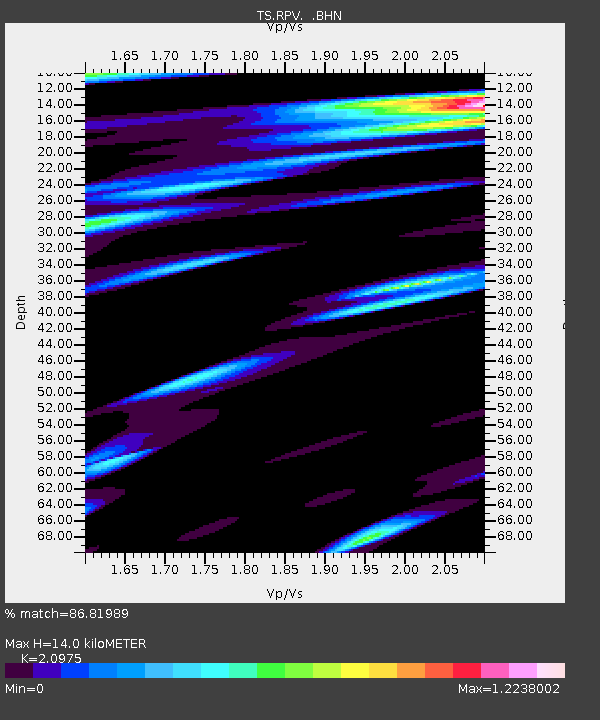
| Estimated Moho Depth: |
14.0 km |
| Estimated Crust Vp/Vs: |
2.10 |
| Assumed Crust Vp: |
6.048 km/s |
| Estimated Crust Vs: |
2.883 km/s |
| Estimated Crust Poisson's Ratio: |
0.35 |
|
| Radial Match: |
86.81989 % |
| Radial Bump: |
400 |
| Transverse Match: |
65.57109 % |
| Transverse Bump: |
400 |
| SOD ConfigId: |
6273 |
| Insert Time: |
2010-02-26 14:45:07.486 +0000 |
| GWidth: |
2.5 |
| Max Bumps: |
400 |
| Tol: |
0.001 |
|
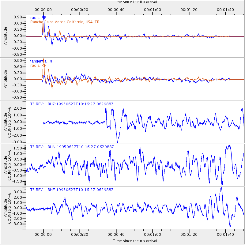
Signal To Noise
| Channel | StoN | STA | LTA |
| TS:RPV: :BHN:19950627T10:16:27.062988Z | 0.6573939 | 2.5781222E-7 | 3.9217315E-7 |
| TS:RPV: :BHE:19950627T10:16:27.062988Z | 1.0882429 | 2.7479425E-7 | 2.5251188E-7 |
| TS:RPV: :BHZ:19950627T10:16:27.062988Z | 6.7013965 | 6.8256645E-7 | 1.0185436E-7 |
| Arrivals |
| Ps | 2.7 SECOND |
| PpPs | 6.8 SECOND |
| PsPs/PpSs | 9.5 SECOND |


