You are here: Home > Network List > IW - Intermountain West Stations List
> Station RWWY Rawlins, Wyoming, USA > Earthquake Result Viewer
RWWY Rawlins, Wyoming, USA - Earthquake Result Viewer
| Earthquake location: |
Vanuatu Islands |
| Earthquake latitude/longitude: |
-14.6/167.4 |
| Earthquake time(UTC): |
2017/05/09 (129) 13:52:10 GMT |
| Earthquake Depth: |
169 km |
| Earthquake Magnitude: |
6.8 mww |
| Earthquake Catalog/Contributor: |
NEIC PDE/us |
|
| Network: |
IW Intermountain West |
| Station: |
RWWY Rawlins, Wyoming, USA |
| Lat/Lon: |
41.69 N/107.21 W |
| Elevation: |
2402 m |
|
| Distance: |
96.2 deg |
| Az: |
48.675 deg |
| Baz: |
256.098 deg |
| Ray Param: |
0.04044033 |
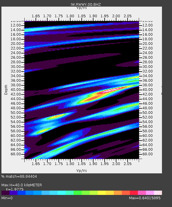
| Estimated Moho Depth: |
40.0 km |
| Estimated Crust Vp/Vs: |
1.98 |
| Assumed Crust Vp: |
6.159 km/s |
| Estimated Crust Vs: |
3.114 km/s |
| Estimated Crust Poisson's Ratio: |
0.33 |
|
| Radial Match: |
88.84404 % |
| Radial Bump: |
304 |
| Transverse Match: |
74.33469 % |
| Transverse Bump: |
400 |
| SOD ConfigId: |
2028011 |
| Insert Time: |
2017-05-23 13:55:10.991 +0000 |
| GWidth: |
2.5 |
| Max Bumps: |
400 |
| Tol: |
0.001 |
|

Signal To Noise
| Channel | StoN | STA | LTA |
| IW:RWWY:00:BHZ:20170509T14:04:48.264971Z | 11.603665 | 1.679482E-6 | 1.447372E-7 |
| IW:RWWY:00:BH1:20170509T14:04:48.264971Z | 1.2251346 | 3.0496977E-7 | 2.4892756E-7 |
| IW:RWWY:00:BH2:20170509T14:04:48.264971Z | 2.4736862 | 4.679915E-7 | 1.8918789E-7 |
| Arrivals |
| Ps | 6.5 SECOND |
| PpPs | 19 SECOND |
| PsPs/PpSs | 25 SECOND |


