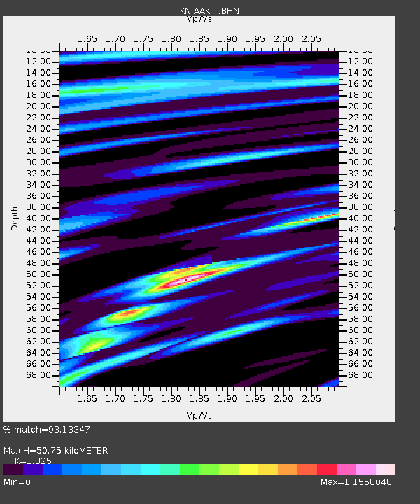
AAK KN.AAK - Earthquake Result Viewer

Earthquake location: Southern Sumatra, Indonesia
Earthquake latitude/longitude: -2.0/100.1
Earthquake time(UTC): 2007/09/20 (263) 08:31:14 GMT
Earthquake Depth: 30 km
Earthquake Magnitude: 6.3 MB, 6.8 MS, 6.7 MW, 6.3 ME
Earthquake Catalog/Contributor: WHDF/NEIC
Network: KN Kyrgyz Seismic Telemetry Network
Station: AAK KN.AAK
Lat/Lon: 42.63 N/74.49 E
Elevation: 1680 m
Distance: 50.1 deg
Az: 335.395 deg
Baz: 145.677 deg
Ray Param: 0.0682275
Estimated Moho Depth: 50.75 km
Estimated Crust Vp/Vs: 1.83
Assumed Crust Vp: 6.306 km/s
Estimated Crust Vs: 3.455 km/s
Estimated Crust Poisson's Ratio: 0.29
Radial Match: 93.13347 %
Radial Bump: 285
Transverse Match: 92.76939 %
Transverse Bump: 400
SOD ConfigId: 2564
Insert Time: 2010-03-08 18:40:11.241 +0000
GWidth: 2.5
Max Bumps: 400
Tol: 0.001

Signal To Noise

ChannelStoNSTALTA
KN:AAK: :BHN:20070920T08:39:36.025004Z6.45467763.4634886E-75.3658585E-8
KN:AAK: :BHE:20070920T08:39:36.025004Z7.4314852.4843177E-73.3429625E-8
KN:AAK: :BHZ:20070920T08:39:36.025004Z18.952958.024666E-74.2339934E-8
Arrivals
Ps7.0 SECOND
PpPs22 SECOND
PsPs/PpSs29 SECOND