You are here: Home > Network List > TS - TERRAscope (Southern California Seismic Network) Stations List
> Station RPV Rancho Palos Verde California, USA > Earthquake Result Viewer
RPV Rancho Palos Verde California, USA - Earthquake Result Viewer
| Earthquake location: |
New Ireland Region, P.N.G. |
| Earthquake latitude/longitude: |
-4.0/153.9 |
| Earthquake time(UTC): |
1995/06/24 (175) 06:58:06 GMT |
| Earthquake Depth: |
386 km |
| Earthquake Magnitude: |
6.2 MB, 6.8 UNKNOWN |
| Earthquake Catalog/Contributor: |
WHDF/NEIC |
|
| Network: |
TS TERRAscope (Southern California Seismic Network) |
| Station: |
RPV Rancho Palos Verde California, USA |
| Lat/Lon: |
33.74 N/118.40 W |
| Elevation: |
115 m |
|
| Distance: |
90.2 deg |
| Az: |
56.362 deg |
| Baz: |
265.409 deg |
| Ray Param: |
0.041591946 |
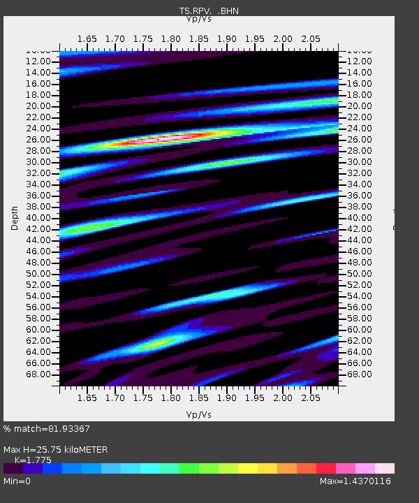
| Estimated Moho Depth: |
25.75 km |
| Estimated Crust Vp/Vs: |
1.77 |
| Assumed Crust Vp: |
6.048 km/s |
| Estimated Crust Vs: |
3.407 km/s |
| Estimated Crust Poisson's Ratio: |
0.27 |
|
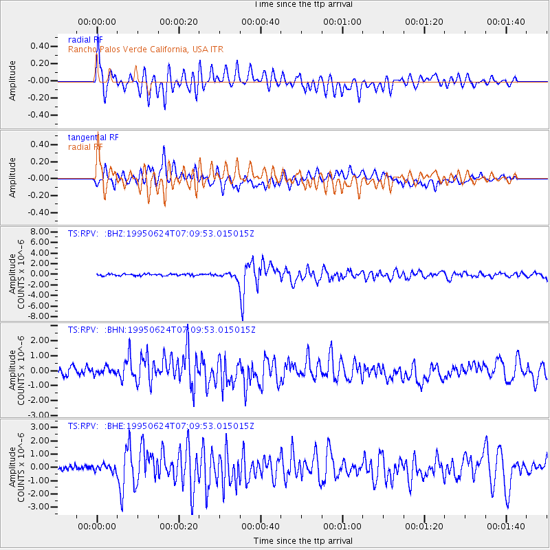
| Radial Match: |
81.93367 % |
| Radial Bump: |
400 |
| Transverse Match: |
74.00753 % |
| Transverse Bump: |
400 |
| SOD ConfigId: |
6273 |
| Insert Time: |
2010-02-26 14:45:16.357 +0000 |
| GWidth: |
2.5 |
| Max Bumps: |
400 |
| Tol: |
0.001 |
|
Signal To Noise
| Channel | StoN | STA | LTA |
| TS:RPV: :BHN:19950624T07:09:53.015015Z | 0.89524233 | 3.713965E-7 | 4.1485583E-7 |
| TS:RPV: :BHE:19950624T07:09:53.015015Z | 1.0193043 | 2.823541E-7 | 2.770067E-7 |
| TS:RPV: :BHZ:19950624T07:09:53.015015Z | 3.5817323 | 5.74441E-7 | 1.6038078E-7 |
| Arrivals |
| Ps | 3.4 SECOND |
| PpPs | 12 SECOND |
| PsPs/PpSs | 15 SECOND |


