You are here: Home > Network List > TA - USArray Transportable Network (new EarthScope stations) Stations List
> Station G21K Allakaket, AK, USA > Earthquake Result Viewer
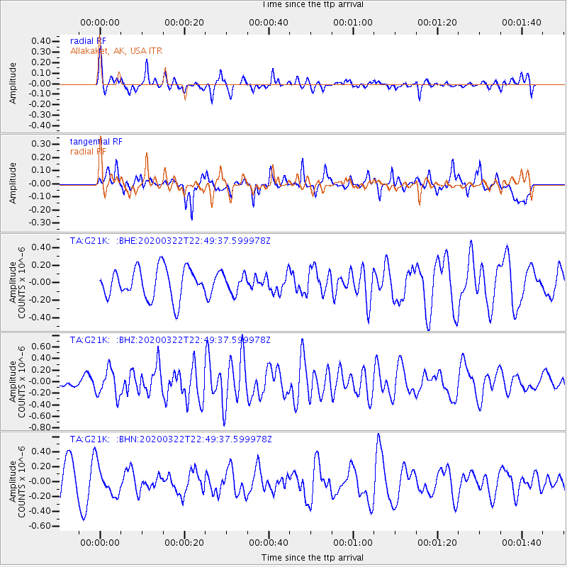
G21K Allakaket, AK, USA - Earthquake Result Viewer
*The percent match for this event was below the threshold and hence no stack was calculated.
| Earthquake location: |
Central East Pacific Rise |
| Earthquake latitude/longitude: |
-4.7/-105.0 |
| Earthquake time(UTC): |
2020/03/22 (082) 22:38:04 GMT |
| Earthquake Depth: |
10 km |
| Earthquake Magnitude: |
6.1 mww |
| Earthquake Catalog/Contributor: |
NEIC PDE/us |
|
| Network: |
TA USArray Transportable Network (new EarthScope stations) |
| Station: |
G21K Allakaket, AK, USA |
| Lat/Lon: |
66.52 N/153.51 W |
| Elevation: |
446 m |
|
| Distance: |
79.0 deg |
| Az: |
342.183 deg |
| Baz: |
130.446 deg |
| Ray Param: |
$rayparam |
*The percent match for this event was below the threshold and hence was not used in the summary stack. |
|
| Radial Match: |
49.41605 % |
| Radial Bump: |
400 |
| Transverse Match: |
58.33379 % |
| Transverse Bump: |
387 |
| SOD ConfigId: |
20906531 |
| Insert Time: |
2020-04-08 14:42:16.196 +0000 |
| GWidth: |
2.5 |
| Max Bumps: |
400 |
| Tol: |
0.001 |
|
Signal To Noise
| Channel | StoN | STA | LTA |
| TA:G21K: :BHZ:20200322T22:49:37.599978Z | 1.7491482 | 2.3719052E-7 | 1.3560344E-7 |
| TA:G21K: :BHN:20200322T22:49:37.599978Z | 1.0003587 | 1.8818423E-7 | 1.8811676E-7 |
| TA:G21K: :BHE:20200322T22:49:37.599978Z | 0.6104734 | 1.04221606E-7 | 1.707226E-7 |
| Arrivals |
| Ps | |
| PpPs | |
| PsPs/PpSs | |


