You are here: Home > Network List > TS - TERRAscope (Southern California Seismic Network) Stations List
> Station RPV Rancho Palos Verde California, USA > Earthquake Result Viewer
RPV Rancho Palos Verde California, USA - Earthquake Result Viewer
| Earthquake location: |
Tonga Islands |
| Earthquake latitude/longitude: |
-21.1/-175.5 |
| Earthquake time(UTC): |
1995/07/28 (209) 14:29:12 GMT |
| Earthquake Depth: |
102 km |
| Earthquake Magnitude: |
6.1 MB, 6.5 UNKNOWN, 6.4 MW |
| Earthquake Catalog/Contributor: |
WHDF/NEIC |
|
| Network: |
TS TERRAscope (Southern California Seismic Network) |
| Station: |
RPV Rancho Palos Verde California, USA |
| Lat/Lon: |
33.74 N/118.40 W |
| Elevation: |
115 m |
|
| Distance: |
77.0 deg |
| Az: |
45.879 deg |
| Baz: |
233.56 deg |
| Ray Param: |
0.05038472 |
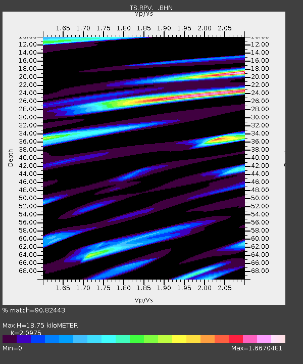
| Estimated Moho Depth: |
18.75 km |
| Estimated Crust Vp/Vs: |
2.10 |
| Assumed Crust Vp: |
6.048 km/s |
| Estimated Crust Vs: |
2.883 km/s |
| Estimated Crust Poisson's Ratio: |
0.35 |
|
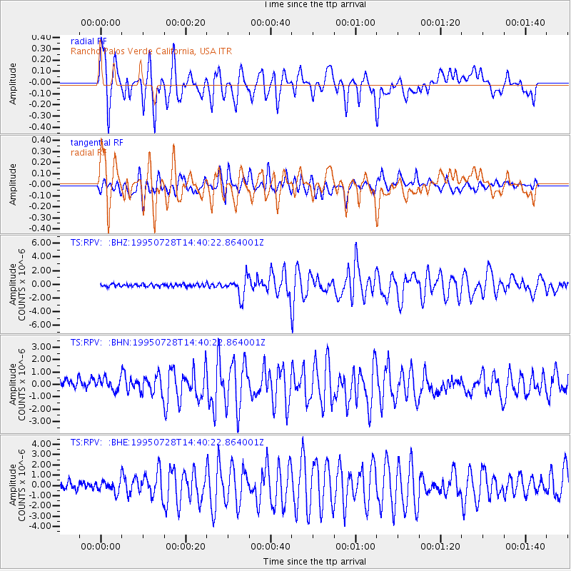
| Radial Match: |
90.82443 % |
| Radial Bump: |
400 |
| Transverse Match: |
79.17409 % |
| Transverse Bump: |
400 |
| SOD ConfigId: |
6273 |
| Insert Time: |
2010-02-26 14:45:18.353 +0000 |
| GWidth: |
2.5 |
| Max Bumps: |
400 |
| Tol: |
0.001 |
|
Signal To Noise
| Channel | StoN | STA | LTA |
| TS:RPV: :BHN:19950728T14:40:22.864001Z | 1.4106278 | 5.5263644E-7 | 3.9176626E-7 |
| TS:RPV: :BHE:19950728T14:40:22.864001Z | 1.7203051 | 6.107785E-7 | 3.5504078E-7 |
| TS:RPV: :BHZ:19950728T14:40:22.864001Z | 7.4667425 | 1.4537434E-6 | 1.946958E-7 |
| Arrivals |
| Ps | 3.5 SECOND |
| PpPs | 9.4 SECOND |
| PsPs/PpSs | 13 SECOND |


