You are here: Home > Network List > AE - Arizona Broadband Seismic Network Stations List
> Station BABIT Valle/Cataract Creek > Earthquake Result Viewer
BABIT Valle/Cataract Creek - Earthquake Result Viewer
| Earthquake location: |
East Of Kuril Islands |
| Earthquake latitude/longitude: |
49.0/157.7 |
| Earthquake time(UTC): |
2020/03/25 (085) 02:49:21 GMT |
| Earthquake Depth: |
57 km |
| Earthquake Magnitude: |
7.5 Mww |
| Earthquake Catalog/Contributor: |
NEIC PDE/us |
|
| Network: |
AE Arizona Broadband Seismic Network |
| Station: |
BABIT Valle/Cataract Creek |
| Lat/Lon: |
35.75 N/112.42 W |
| Elevation: |
1694 m |
|
| Distance: |
64.0 deg |
| Az: |
64.852 deg |
| Baz: |
312.859 deg |
| Ray Param: |
0.059091598 |
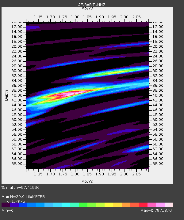
| Estimated Moho Depth: |
39.0 km |
| Estimated Crust Vp/Vs: |
1.80 |
| Assumed Crust Vp: |
6.276 km/s |
| Estimated Crust Vs: |
3.491 km/s |
| Estimated Crust Poisson's Ratio: |
0.28 |
|
| Radial Match: |
97.41936 % |
| Radial Bump: |
277 |
| Transverse Match: |
84.85381 % |
| Transverse Bump: |
400 |
| SOD ConfigId: |
20906531 |
| Insert Time: |
2020-04-08 14:46:47.008 +0000 |
| GWidth: |
2.5 |
| Max Bumps: |
400 |
| Tol: |
0.001 |
|

Signal To Noise
| Channel | StoN | STA | LTA |
| AE:BABIT: :HHZ:20200325T02:59:18.000012Z | 43.27959 | 8.7609615E-6 | 2.0242709E-7 |
| AE:BABIT: :HHN:20200325T02:59:18.000012Z | 26.999832 | 2.8623517E-6 | 1.0601369E-7 |
| AE:BABIT: :HHE:20200325T02:59:18.000012Z | 20.34098 | 3.2504595E-6 | 1.5979856E-7 |
| Arrivals |
| Ps | 5.2 SECOND |
| PpPs | 17 SECOND |
| PsPs/PpSs | 22 SECOND |


