You are here: Home > Network List > AE - Arizona Broadband Seismic Network Stations List
> Station X16A Lo Mia Camp, Pine, AZ, USA > Earthquake Result Viewer
X16A Lo Mia Camp, Pine, AZ, USA - Earthquake Result Viewer
| Earthquake location: |
East Of Kuril Islands |
| Earthquake latitude/longitude: |
49.0/157.7 |
| Earthquake time(UTC): |
2020/03/25 (085) 02:49:21 GMT |
| Earthquake Depth: |
57 km |
| Earthquake Magnitude: |
7.5 Mww |
| Earthquake Catalog/Contributor: |
NEIC PDE/us |
|
| Network: |
AE Arizona Broadband Seismic Network |
| Station: |
X16A Lo Mia Camp, Pine, AZ, USA |
| Lat/Lon: |
34.42 N/111.44 W |
| Elevation: |
1759 m |
|
| Distance: |
65.5 deg |
| Az: |
65.309 deg |
| Baz: |
313.615 deg |
| Ray Param: |
0.05811426 |
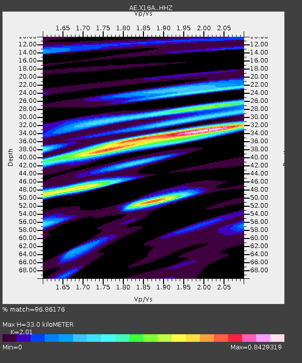
| Estimated Moho Depth: |
33.0 km |
| Estimated Crust Vp/Vs: |
2.01 |
| Assumed Crust Vp: |
6.207 km/s |
| Estimated Crust Vs: |
3.088 km/s |
| Estimated Crust Poisson's Ratio: |
0.34 |
|
| Radial Match: |
96.86176 % |
| Radial Bump: |
400 |
| Transverse Match: |
85.393486 % |
| Transverse Bump: |
400 |
| SOD ConfigId: |
20906531 |
| Insert Time: |
2020-04-08 14:47:00.899 +0000 |
| GWidth: |
2.5 |
| Max Bumps: |
400 |
| Tol: |
0.001 |
|

Signal To Noise
| Channel | StoN | STA | LTA |
| AE:X16A: :HHZ:20200325T02:59:27.700024Z | 34.410282 | 7.869653E-6 | 2.2870064E-7 |
| AE:X16A: :HHN:20200325T02:59:27.700024Z | 18.09797 | 2.2809422E-6 | 1.2603304E-7 |
| AE:X16A: :HHE:20200325T02:59:27.700024Z | 13.022699 | 2.3464047E-6 | 1.8017806E-7 |
| Arrivals |
| Ps | 5.6 SECOND |
| PpPs | 15 SECOND |
| PsPs/PpSs | 21 SECOND |


