You are here: Home > Network List > AG - Arkansas Seismic Network Stations List
> Station WHAR Woolly Hollow State Park,AR > Earthquake Result Viewer
WHAR Woolly Hollow State Park,AR - Earthquake Result Viewer
| Earthquake location: |
East Of Kuril Islands |
| Earthquake latitude/longitude: |
49.0/157.7 |
| Earthquake time(UTC): |
2020/03/25 (085) 02:49:21 GMT |
| Earthquake Depth: |
57 km |
| Earthquake Magnitude: |
7.5 Mww |
| Earthquake Catalog/Contributor: |
NEIC PDE/us |
|
| Network: |
AG Arkansas Seismic Network |
| Station: |
WHAR Woolly Hollow State Park,AR |
| Lat/Lon: |
35.29 N/92.29 W |
| Elevation: |
184 m |
|
| Distance: |
75.6 deg |
| Az: |
52.512 deg |
| Baz: |
320.287 deg |
| Ray Param: |
0.05143599 |
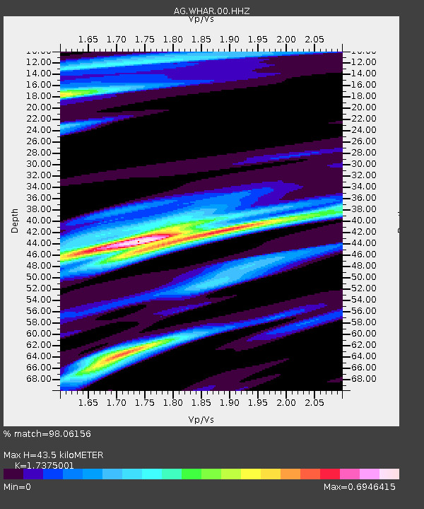
| Estimated Moho Depth: |
43.5 km |
| Estimated Crust Vp/Vs: |
1.74 |
| Assumed Crust Vp: |
6.498 km/s |
| Estimated Crust Vs: |
3.74 km/s |
| Estimated Crust Poisson's Ratio: |
0.25 |
|
| Radial Match: |
98.06156 % |
| Radial Bump: |
237 |
| Transverse Match: |
93.031006 % |
| Transverse Bump: |
300 |
| SOD ConfigId: |
20906531 |
| Insert Time: |
2020-04-08 14:47:12.343 +0000 |
| GWidth: |
2.5 |
| Max Bumps: |
400 |
| Tol: |
0.001 |
|

Signal To Noise
| Channel | StoN | STA | LTA |
| AG:WHAR:00:HHZ:20200325T03:00:29.320019Z | 54.80513 | 1.4291705E-5 | 2.6077313E-7 |
| AG:WHAR:00:HHN:20200325T03:00:29.320019Z | 21.081264 | 4.5831484E-6 | 2.1740387E-7 |
| AG:WHAR:00:HHE:20200325T03:00:29.320019Z | 25.02091 | 3.715241E-6 | 1.4848546E-7 |
| Arrivals |
| Ps | 5.1 SECOND |
| PpPs | 18 SECOND |
| PsPs/PpSs | 23 SECOND |


