You are here: Home > Network List > AK - Alaska Regional Network Stations List
> Station KLU Klutina Pass, Alaska, USA > Earthquake Result Viewer
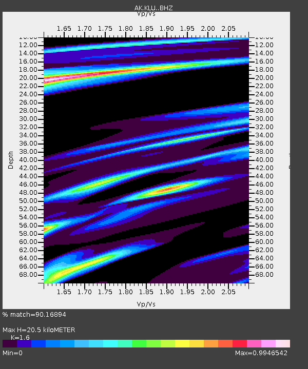
KLU Klutina Pass, Alaska, USA - Earthquake Result Viewer
| Earthquake location: |
East Of Kuril Islands |
| Earthquake latitude/longitude: |
49.0/157.7 |
| Earthquake time(UTC): |
2020/03/25 (085) 02:49:21 GMT |
| Earthquake Depth: |
57 km |
| Earthquake Magnitude: |
7.5 Mww |
| Earthquake Catalog/Contributor: |
NEIC PDE/us |
|
| Network: |
AK Alaska Regional Network |
| Station: |
KLU Klutina Pass, Alaska, USA |
| Lat/Lon: |
61.49 N/145.92 W |
| Elevation: |
1021 m |
|
| Distance: |
33.4 deg |
| Az: |
46.573 deg |
| Baz: |
274.271 deg |
| Ray Param: |
0.07812138 |
| Estimated Moho Depth: |
20.5 km |
| Estimated Crust Vp/Vs: |
1.60 |
| Assumed Crust Vp: |
6.566 km/s |
| Estimated Crust Vs: |
4.104 km/s |
| Estimated Crust Poisson's Ratio: |
0.18 |
|
| Radial Match: |
90.16894 % |
| Radial Bump: |
257 |
| Transverse Match: |
72.17929 % |
| Transverse Bump: |
393 |
| SOD ConfigId: |
20906531 |
| Insert Time: |
2020-04-08 14:48:25.925 +0000 |
| GWidth: |
2.5 |
| Max Bumps: |
400 |
| Tol: |
0.001 |
|

Signal To Noise
| Channel | StoN | STA | LTA |
| AK:KLU: :BHZ:20200325T02:55:23.94801Z | 53.357933 | 1.851058E-5 | 3.4691337E-7 |
| AK:KLU: :BHN:20200325T02:55:23.94801Z | 8.957727 | 1.0085691E-6 | 1.12592076E-7 |
| AK:KLU: :BHE:20200325T02:55:23.94801Z | 41.463886 | 1.31330435E-5 | 3.167345E-7 |
| Arrivals |
| Ps | 2.1 SECOND |
| PpPs | 7.4 SECOND |
| PsPs/PpSs | 9.5 SECOND |


