You are here: Home > Network List > AK - Alaska Regional Network Stations List
> Station R32K Eaglecrest, AK, USA > Earthquake Result Viewer
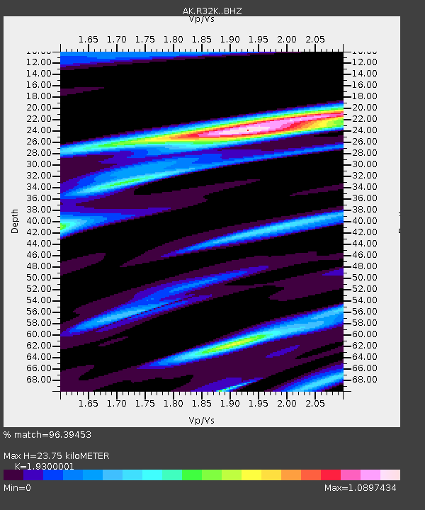
R32K Eaglecrest, AK, USA - Earthquake Result Viewer
| Earthquake location: |
East Of Kuril Islands |
| Earthquake latitude/longitude: |
49.0/157.7 |
| Earthquake time(UTC): |
2020/03/25 (085) 02:49:21 GMT |
| Earthquake Depth: |
57 km |
| Earthquake Magnitude: |
7.5 Mww |
| Earthquake Catalog/Contributor: |
NEIC PDE/us |
|
| Network: |
AK Alaska Regional Network |
| Station: |
R32K Eaglecrest, AK, USA |
| Lat/Lon: |
58.27 N/134.52 W |
| Elevation: |
386 m |
|
| Distance: |
39.6 deg |
| Az: |
50.103 deg |
| Baz: |
286.973 deg |
| Ray Param: |
0.074722014 |
| Estimated Moho Depth: |
23.75 km |
| Estimated Crust Vp/Vs: |
1.93 |
| Assumed Crust Vp: |
6.566 km/s |
| Estimated Crust Vs: |
3.402 km/s |
| Estimated Crust Poisson's Ratio: |
0.32 |
|
| Radial Match: |
96.39453 % |
| Radial Bump: |
232 |
| Transverse Match: |
85.73257 % |
| Transverse Bump: |
400 |
| SOD ConfigId: |
20906531 |
| Insert Time: |
2020-04-08 14:48:55.026 +0000 |
| GWidth: |
2.5 |
| Max Bumps: |
400 |
| Tol: |
0.001 |
|

Signal To Noise
| Channel | StoN | STA | LTA |
| AK:R32K: :BHZ:20200325T02:56:16.960003Z | 91.59309 | 1.2891833E-5 | 1.4075115E-7 |
| AK:R32K: :BHN:20200325T02:56:16.960003Z | 14.022024 | 2.5059824E-6 | 1.7871758E-7 |
| AK:R32K: :BHE:20200325T02:56:16.960003Z | 50.33659 | 8.912662E-6 | 1.7706132E-7 |
| Arrivals |
| Ps | 3.6 SECOND |
| PpPs | 9.9 SECOND |
| PsPs/PpSs | 14 SECOND |


