You are here: Home > Network List > AK - Alaska Regional Network Stations List
> Station RC01 Rabbit Creek > Earthquake Result Viewer
RC01 Rabbit Creek - Earthquake Result Viewer
| Earthquake location: |
East Of Kuril Islands |
| Earthquake latitude/longitude: |
49.0/157.7 |
| Earthquake time(UTC): |
2020/03/25 (085) 02:49:21 GMT |
| Earthquake Depth: |
57 km |
| Earthquake Magnitude: |
7.5 Mww |
| Earthquake Catalog/Contributor: |
NEIC PDE/us |
|
| Network: |
AK Alaska Regional Network |
| Station: |
RC01 Rabbit Creek |
| Lat/Lon: |
61.09 N/149.74 W |
| Elevation: |
383 m |
|
| Distance: |
31.6 deg |
| Az: |
47.505 deg |
| Baz: |
271.716 deg |
| Ray Param: |
0.07891645 |
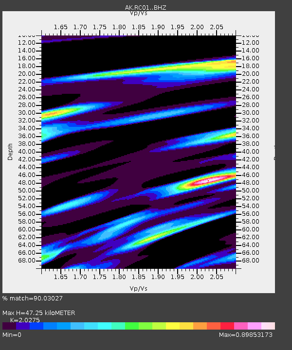
| Estimated Moho Depth: |
47.25 km |
| Estimated Crust Vp/Vs: |
2.03 |
| Assumed Crust Vp: |
6.566 km/s |
| Estimated Crust Vs: |
3.239 km/s |
| Estimated Crust Poisson's Ratio: |
0.34 |
|
| Radial Match: |
90.03027 % |
| Radial Bump: |
343 |
| Transverse Match: |
76.20712 % |
| Transverse Bump: |
400 |
| SOD ConfigId: |
20906531 |
| Insert Time: |
2020-04-08 14:48:57.786 +0000 |
| GWidth: |
2.5 |
| Max Bumps: |
400 |
| Tol: |
0.001 |
|

Signal To Noise
| Channel | StoN | STA | LTA |
| AK:RC01: :BHZ:20200325T02:55:08.079998Z | 86.38058 | 1.5992608E-5 | 1.8514125E-7 |
| AK:RC01: :BHN:20200325T02:55:08.079998Z | 13.29155 | 1.8894552E-6 | 1.4215462E-7 |
| AK:RC01: :BHE:20200325T02:55:08.079998Z | 42.802116 | 9.626008E-6 | 2.2489563E-7 |
| Arrivals |
| Ps | 8.0 SECOND |
| PpPs | 20 SECOND |
| PsPs/PpSs | 28 SECOND |


