You are here: Home > Network List > AK - Alaska Regional Network Stations List
> Station SUCK Suckling Hills, AK, USA > Earthquake Result Viewer
SUCK Suckling Hills, AK, USA - Earthquake Result Viewer
| Earthquake location: |
East Of Kuril Islands |
| Earthquake latitude/longitude: |
49.0/157.7 |
| Earthquake time(UTC): |
2020/03/25 (085) 02:49:21 GMT |
| Earthquake Depth: |
57 km |
| Earthquake Magnitude: |
7.5 Mww |
| Earthquake Catalog/Contributor: |
NEIC PDE/us |
|
| Network: |
AK Alaska Regional Network |
| Station: |
SUCK Suckling Hills, AK, USA |
| Lat/Lon: |
60.07 N/143.78 W |
| Elevation: |
467 m |
|
| Distance: |
34.6 deg |
| Az: |
48.907 deg |
| Baz: |
278.074 deg |
| Ray Param: |
0.07753365 |
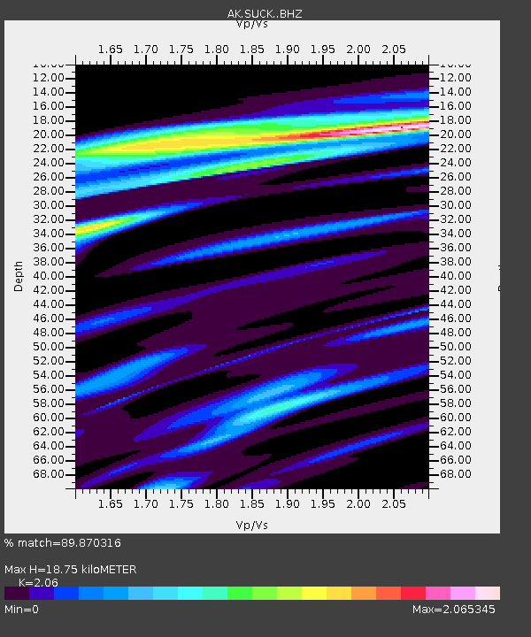
| Estimated Moho Depth: |
18.75 km |
| Estimated Crust Vp/Vs: |
2.06 |
| Assumed Crust Vp: |
6.566 km/s |
| Estimated Crust Vs: |
3.187 km/s |
| Estimated Crust Poisson's Ratio: |
0.35 |
|
| Radial Match: |
89.870316 % |
| Radial Bump: |
331 |
| Transverse Match: |
72.04815 % |
| Transverse Bump: |
400 |
| SOD ConfigId: |
20906531 |
| Insert Time: |
2020-04-08 14:49:13.966 +0000 |
| GWidth: |
2.5 |
| Max Bumps: |
400 |
| Tol: |
0.001 |
|

Signal To Noise
| Channel | StoN | STA | LTA |
| AK:SUCK: :BHZ:20200325T02:55:34.307995Z | 73.04052 | 1.967861E-5 | 2.6942047E-7 |
| AK:SUCK: :BHN:20200325T02:55:34.307995Z | 6.78783 | 1.705728E-6 | 2.512921E-7 |
| AK:SUCK: :BHE:20200325T02:55:34.307995Z | 22.14537 | 9.627664E-6 | 4.347484E-7 |
| Arrivals |
| Ps | 3.2 SECOND |
| PpPs | 8.2 SECOND |
| PsPs/PpSs | 11 SECOND |


