You are here: Home > Network List > AK - Alaska Regional Network Stations List
> Station TRF Thorofare Mountian, AK, USA > Earthquake Result Viewer
TRF Thorofare Mountian, AK, USA - Earthquake Result Viewer
| Earthquake location: |
East Of Kuril Islands |
| Earthquake latitude/longitude: |
49.0/157.7 |
| Earthquake time(UTC): |
2020/03/25 (085) 02:49:21 GMT |
| Earthquake Depth: |
57 km |
| Earthquake Magnitude: |
7.5 Mww |
| Earthquake Catalog/Contributor: |
NEIC PDE/us |
|
| Network: |
AK Alaska Regional Network |
| Station: |
TRF Thorofare Mountian, AK, USA |
| Lat/Lon: |
63.45 N/150.29 W |
| Elevation: |
1710 m |
|
| Distance: |
31.3 deg |
| Az: |
42.957 deg |
| Baz: |
267.346 deg |
| Ray Param: |
0.07901105 |
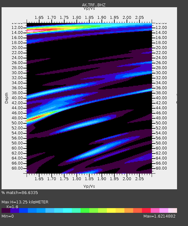
| Estimated Moho Depth: |
13.25 km |
| Estimated Crust Vp/Vs: |
1.60 |
| Assumed Crust Vp: |
6.438 km/s |
| Estimated Crust Vs: |
4.024 km/s |
| Estimated Crust Poisson's Ratio: |
0.18 |
|
| Radial Match: |
86.6335 % |
| Radial Bump: |
400 |
| Transverse Match: |
73.47393 % |
| Transverse Bump: |
400 |
| SOD ConfigId: |
20906531 |
| Insert Time: |
2020-04-08 14:49:17.214 +0000 |
| GWidth: |
2.5 |
| Max Bumps: |
400 |
| Tol: |
0.001 |
|

Signal To Noise
| Channel | StoN | STA | LTA |
| AK:TRF: :BHZ:20200325T02:55:05.987988Z | 75.72924 | 1.9003177E-5 | 2.509358E-7 |
| AK:TRF: :BHN:20200325T02:55:05.987988Z | 13.041031 | 1.5396363E-6 | 1.1806093E-7 |
| AK:TRF: :BHE:20200325T02:55:05.987988Z | 37.707577 | 1.105819E-5 | 2.9326176E-7 |
| Arrivals |
| Ps | 1.4 SECOND |
| PpPs | 4.9 SECOND |
| PsPs/PpSs | 6.2 SECOND |


