You are here: Home > Network List > AU - Australian Seismological Centre Stations List
> Station PSAC1 Pilbara Seismic Array Element C1 > Earthquake Result Viewer
PSAC1 Pilbara Seismic Array Element C1 - Earthquake Result Viewer
| Earthquake location: |
East Of Kuril Islands |
| Earthquake latitude/longitude: |
49.0/157.7 |
| Earthquake time(UTC): |
2020/03/25 (085) 02:49:21 GMT |
| Earthquake Depth: |
57 km |
| Earthquake Magnitude: |
7.5 Mww |
| Earthquake Catalog/Contributor: |
NEIC PDE/us |
|
| Network: |
AU Australian Seismological Centre |
| Station: |
PSAC1 Pilbara Seismic Array Element C1 |
| Lat/Lon: |
21.53 S/119.81 E |
| Elevation: |
303 m |
|
| Distance: |
77.9 deg |
| Az: |
215.781 deg |
| Baz: |
24.437 deg |
| Ray Param: |
0.04990474 |
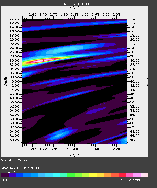
| Estimated Moho Depth: |
29.75 km |
| Estimated Crust Vp/Vs: |
1.70 |
| Assumed Crust Vp: |
6.464 km/s |
| Estimated Crust Vs: |
3.802 km/s |
| Estimated Crust Poisson's Ratio: |
0.24 |
|
| Radial Match: |
96.92432 % |
| Radial Bump: |
376 |
| Transverse Match: |
90.96544 % |
| Transverse Bump: |
400 |
| SOD ConfigId: |
20906531 |
| Insert Time: |
2020-04-08 14:50:18.168 +0000 |
| GWidth: |
2.5 |
| Max Bumps: |
400 |
| Tol: |
0.001 |
|

Signal To Noise
| Channel | StoN | STA | LTA |
| AU:PSAC1:00:BHZ:20200325T03:00:42.11903Z | 32.546875 | 9.908607E-6 | 3.0444113E-7 |
| AU:PSAC1:00:BH1:20200325T03:00:42.11903Z | 25.82811 | 3.3536066E-6 | 1.2984329E-7 |
| AU:PSAC1:00:BH2:20200325T03:00:42.11903Z | 14.839672 | 1.926371E-6 | 1.2981222E-7 |
| Arrivals |
| Ps | 3.3 SECOND |
| PpPs | 12 SECOND |
| PsPs/PpSs | 15 SECOND |


