You are here: Home > Network List > AV - Alaska Volcano Observatory Stations List
> Station SPCR Ckakachatna River, Mount Spurr, Alaska > Earthquake Result Viewer
SPCR Ckakachatna River, Mount Spurr, Alaska - Earthquake Result Viewer
| Earthquake location: |
East Of Kuril Islands |
| Earthquake latitude/longitude: |
49.0/157.7 |
| Earthquake time(UTC): |
2020/03/25 (085) 02:49:21 GMT |
| Earthquake Depth: |
57 km |
| Earthquake Magnitude: |
7.5 Mww |
| Earthquake Catalog/Contributor: |
NEIC PDE/us |
|
| Network: |
AV Alaska Volcano Observatory |
| Station: |
SPCR Ckakachatna River, Mount Spurr, Alaska |
| Lat/Lon: |
61.20 N/152.21 W |
| Elevation: |
984 m |
|
| Distance: |
30.4 deg |
| Az: |
47.311 deg |
| Baz: |
269.388 deg |
| Ray Param: |
0.07935559 |
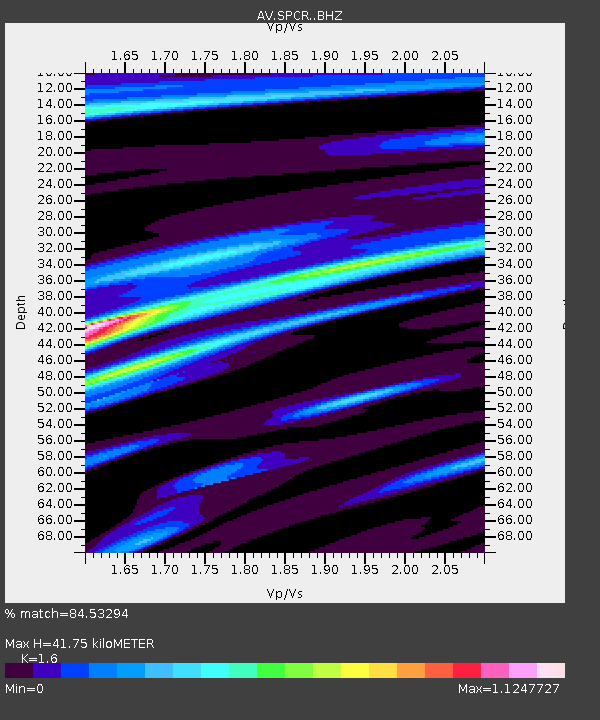
| Estimated Moho Depth: |
41.75 km |
| Estimated Crust Vp/Vs: |
1.60 |
| Assumed Crust Vp: |
6.566 km/s |
| Estimated Crust Vs: |
4.104 km/s |
| Estimated Crust Poisson's Ratio: |
0.18 |
|
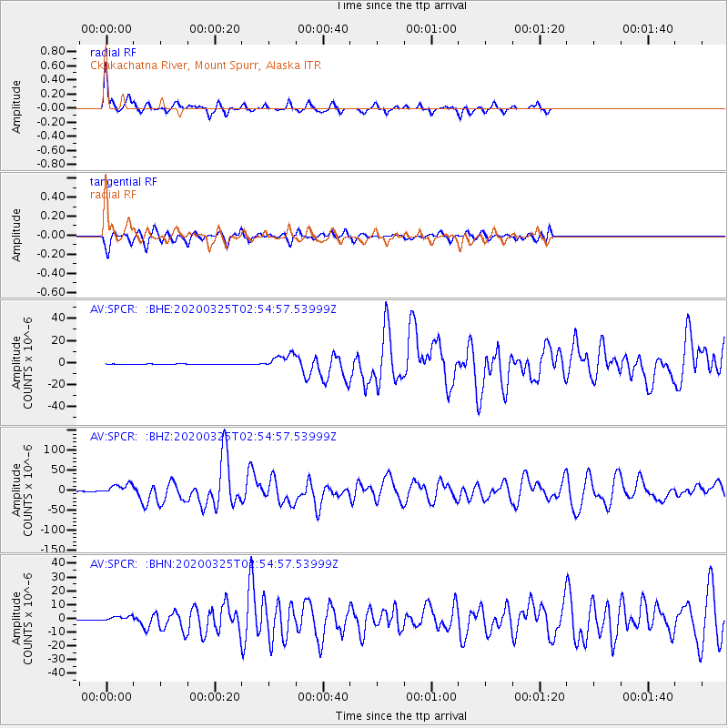
| Radial Match: |
84.53294 % |
| Radial Bump: |
217 |
| Transverse Match: |
77.50366 % |
| Transverse Bump: |
365 |
| SOD ConfigId: |
20906531 |
| Insert Time: |
2020-04-08 14:50:36.218 +0000 |
| GWidth: |
2.5 |
| Max Bumps: |
400 |
| Tol: |
0.001 |
|
Signal To Noise
| Channel | StoN | STA | LTA |
| AV:SPCR: :BHZ:20200325T02:54:57.53999Z | 70.37791 | 1.3441712E-5 | 1.9099336E-7 |
| AV:SPCR: :BHN:20200325T02:54:57.53999Z | 3.3585289 | 1.7615156E-6 | 5.2449025E-7 |
| AV:SPCR: :BHE:20200325T02:54:57.53999Z | 33.18212 | 6.454613E-6 | 1.9452081E-7 |
| Arrivals |
| Ps | 4.2 SECOND |
| PpPs | 15 SECOND |
| PsPs/PpSs | 19 SECOND |


