You are here: Home > Network List > AV - Alaska Volcano Observatory Stations List
> Station STLK Strandline Lake, Regional Station, Alaska > Earthquake Result Viewer
STLK Strandline Lake, Regional Station, Alaska - Earthquake Result Viewer
| Earthquake location: |
East Of Kuril Islands |
| Earthquake latitude/longitude: |
49.0/157.7 |
| Earthquake time(UTC): |
2020/03/25 (085) 02:49:21 GMT |
| Earthquake Depth: |
57 km |
| Earthquake Magnitude: |
7.5 Mww |
| Earthquake Catalog/Contributor: |
NEIC PDE/us |
|
| Network: |
AV Alaska Volcano Observatory |
| Station: |
STLK Strandline Lake, Regional Station, Alaska |
| Lat/Lon: |
61.50 N/151.83 W |
| Elevation: |
945 m |
|
| Distance: |
30.5 deg |
| Az: |
46.726 deg |
| Baz: |
269.211 deg |
| Ray Param: |
0.07929495 |
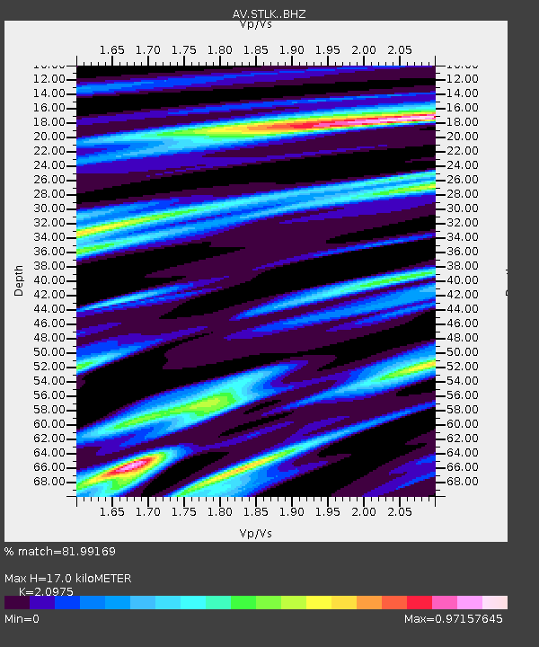
| Estimated Moho Depth: |
17.0 km |
| Estimated Crust Vp/Vs: |
2.10 |
| Assumed Crust Vp: |
6.302 km/s |
| Estimated Crust Vs: |
3.004 km/s |
| Estimated Crust Poisson's Ratio: |
0.35 |
|
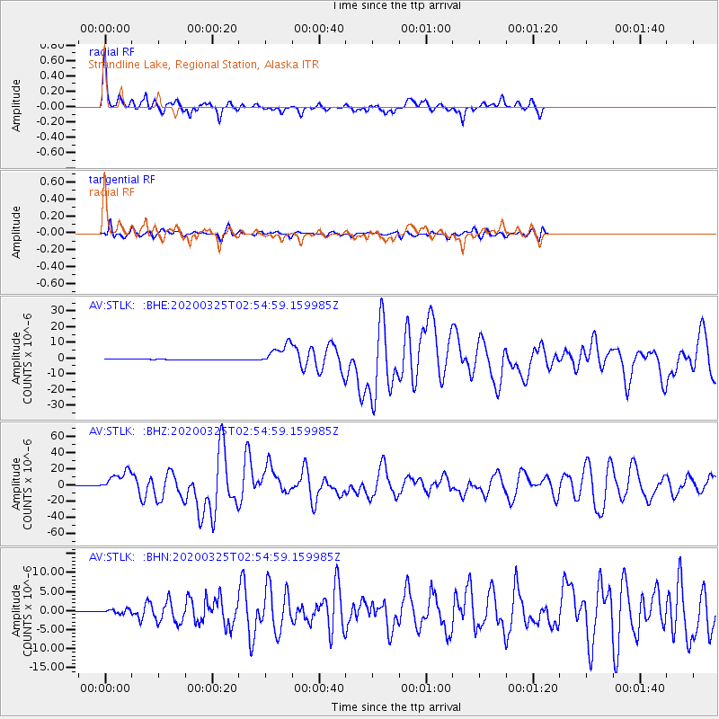
| Radial Match: |
81.99169 % |
| Radial Bump: |
301 |
| Transverse Match: |
77.95573 % |
| Transverse Bump: |
400 |
| SOD ConfigId: |
20906531 |
| Insert Time: |
2020-04-08 14:50:38.399 +0000 |
| GWidth: |
2.5 |
| Max Bumps: |
400 |
| Tol: |
0.001 |
|
Signal To Noise
| Channel | StoN | STA | LTA |
| AV:STLK: :BHZ:20200325T02:54:59.159985Z | 79.60827 | 1.2472918E-5 | 1.5667867E-7 |
| AV:STLK: :BHN:20200325T02:54:59.159985Z | 6.647802 | 5.293304E-7 | 7.9624876E-8 |
| AV:STLK: :BHE:20200325T02:54:59.159985Z | 24.974686 | 6.6786156E-6 | 2.674154E-7 |
| Arrivals |
| Ps | 3.2 SECOND |
| PpPs | 7.8 SECOND |
| PsPs/PpSs | 11 SECOND |


