You are here: Home > Network List > AV - Alaska Volcano Observatory Stations List
> Station WAZA Wrangell Zanetti, Alaska > Earthquake Result Viewer
WAZA Wrangell Zanetti, Alaska - Earthquake Result Viewer
| Earthquake location: |
East Of Kuril Islands |
| Earthquake latitude/longitude: |
49.0/157.7 |
| Earthquake time(UTC): |
2020/03/25 (085) 02:49:21 GMT |
| Earthquake Depth: |
57 km |
| Earthquake Magnitude: |
7.5 Mww |
| Earthquake Catalog/Contributor: |
NEIC PDE/us |
|
| Network: |
AV Alaska Volcano Observatory |
| Station: |
WAZA Wrangell Zanetti, Alaska |
| Lat/Lon: |
62.07 N/144.15 W |
| Elevation: |
2531 m |
|
| Distance: |
34.2 deg |
| Az: |
45.406 deg |
| Baz: |
274.855 deg |
| Ray Param: |
0.07774011 |
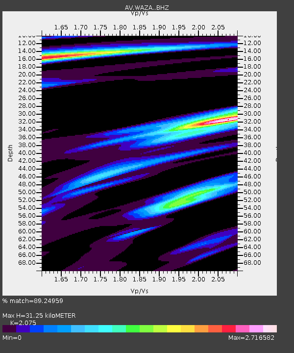
| Estimated Moho Depth: |
31.25 km |
| Estimated Crust Vp/Vs: |
2.08 |
| Assumed Crust Vp: |
6.566 km/s |
| Estimated Crust Vs: |
3.164 km/s |
| Estimated Crust Poisson's Ratio: |
0.35 |
|
| Radial Match: |
89.24959 % |
| Radial Bump: |
342 |
| Transverse Match: |
75.893196 % |
| Transverse Bump: |
400 |
| SOD ConfigId: |
20906531 |
| Insert Time: |
2020-04-08 14:50:41.325 +0000 |
| GWidth: |
2.5 |
| Max Bumps: |
400 |
| Tol: |
0.001 |
|

Signal To Noise
| Channel | StoN | STA | LTA |
| AV:WAZA: :BHZ:20200325T02:55:30.800Z | 99.35916 | 1.73777E-5 | 1.7489783E-7 |
| AV:WAZA: :BHN:20200325T02:55:30.800Z | 5.093565 | 1.0906905E-6 | 2.1413108E-7 |
| AV:WAZA: :BHE:20200325T02:55:30.800Z | 44.200455 | 1.0716837E-5 | 2.424599E-7 |
| Arrivals |
| Ps | 5.5 SECOND |
| PpPs | 14 SECOND |
| PsPs/PpSs | 19 SECOND |


