You are here: Home > Network List > AZ - ANZA Regional Network Stations List
> Station SIO5 Mt. Soledad, La Jolla, CA > Earthquake Result Viewer
SIO5 Mt. Soledad, La Jolla, CA - Earthquake Result Viewer
| Earthquake location: |
East Of Kuril Islands |
| Earthquake latitude/longitude: |
49.0/157.7 |
| Earthquake time(UTC): |
2020/03/25 (085) 02:49:21 GMT |
| Earthquake Depth: |
57 km |
| Earthquake Magnitude: |
7.5 Mww |
| Earthquake Catalog/Contributor: |
NEIC PDE/us |
|
| Network: |
AZ ANZA Regional Network |
| Station: |
SIO5 Mt. Soledad, La Jolla, CA |
| Lat/Lon: |
32.84 N/117.25 W |
| Elevation: |
217 m |
|
| Distance: |
63.0 deg |
| Az: |
70.259 deg |
| Baz: |
312.564 deg |
| Ray Param: |
0.05973143 |
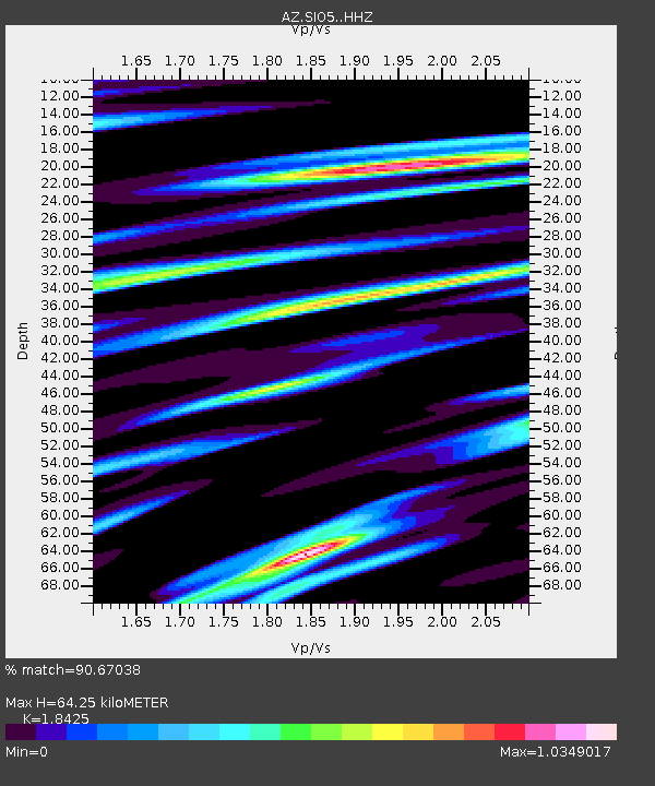
| Estimated Moho Depth: |
64.25 km |
| Estimated Crust Vp/Vs: |
1.84 |
| Assumed Crust Vp: |
6.264 km/s |
| Estimated Crust Vs: |
3.4 km/s |
| Estimated Crust Poisson's Ratio: |
0.29 |
|
| Radial Match: |
90.67038 % |
| Radial Bump: |
400 |
| Transverse Match: |
85.85744 % |
| Transverse Bump: |
400 |
| SOD ConfigId: |
20906531 |
| Insert Time: |
2020-04-08 14:50:46.585 +0000 |
| GWidth: |
2.5 |
| Max Bumps: |
400 |
| Tol: |
0.001 |
|

Signal To Noise
| Channel | StoN | STA | LTA |
| AZ:SIO5: :HHZ:20200325T02:59:11.593029Z | 37.76919 | 1.3903226E-5 | 3.6811025E-7 |
| AZ:SIO5: :HHN:20200325T02:59:11.593029Z | 11.678818 | 6.155211E-6 | 5.270406E-7 |
| AZ:SIO5: :HHE:20200325T02:59:11.593029Z | 6.85735 | 4.236316E-6 | 6.177774E-7 |
| Arrivals |
| Ps | 9.0 SECOND |
| PpPs | 28 SECOND |
| PsPs/PpSs | 37 SECOND |


