You are here: Home > Network List > AZ - ANZA Regional Network Stations List
> Station SMER AZ.SMER > Earthquake Result Viewer
SMER AZ.SMER - Earthquake Result Viewer
| Earthquake location: |
East Of Kuril Islands |
| Earthquake latitude/longitude: |
49.0/157.7 |
| Earthquake time(UTC): |
2020/03/25 (085) 02:49:21 GMT |
| Earthquake Depth: |
57 km |
| Earthquake Magnitude: |
7.5 Mww |
| Earthquake Catalog/Contributor: |
NEIC PDE/us |
|
| Network: |
AZ ANZA Regional Network |
| Station: |
SMER AZ.SMER |
| Lat/Lon: |
33.46 N/117.17 W |
| Elevation: |
355 m |
|
| Distance: |
62.6 deg |
| Az: |
69.699 deg |
| Baz: |
312.351 deg |
| Ray Param: |
0.059958506 |
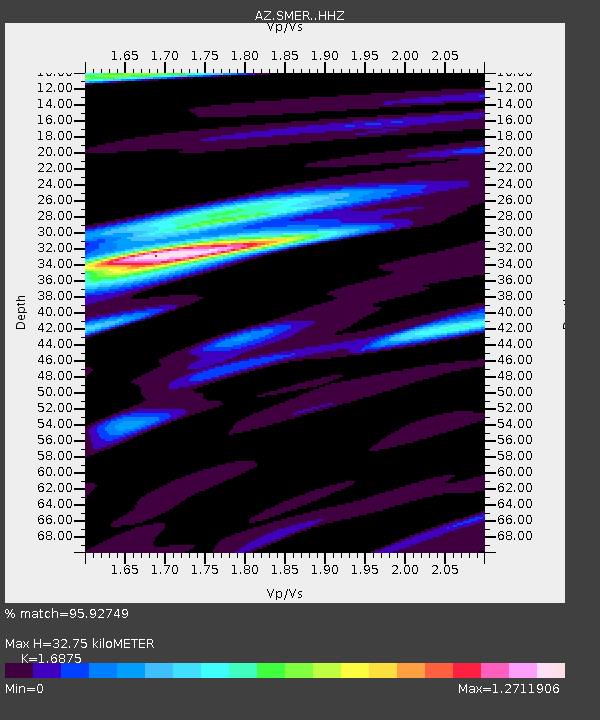
| Estimated Moho Depth: |
32.75 km |
| Estimated Crust Vp/Vs: |
1.69 |
| Assumed Crust Vp: |
6.264 km/s |
| Estimated Crust Vs: |
3.712 km/s |
| Estimated Crust Poisson's Ratio: |
0.23 |
|
| Radial Match: |
95.92749 % |
| Radial Bump: |
339 |
| Transverse Match: |
83.46925 % |
| Transverse Bump: |
400 |
| SOD ConfigId: |
20906531 |
| Insert Time: |
2020-04-08 14:50:46.666 +0000 |
| GWidth: |
2.5 |
| Max Bumps: |
400 |
| Tol: |
0.001 |
|
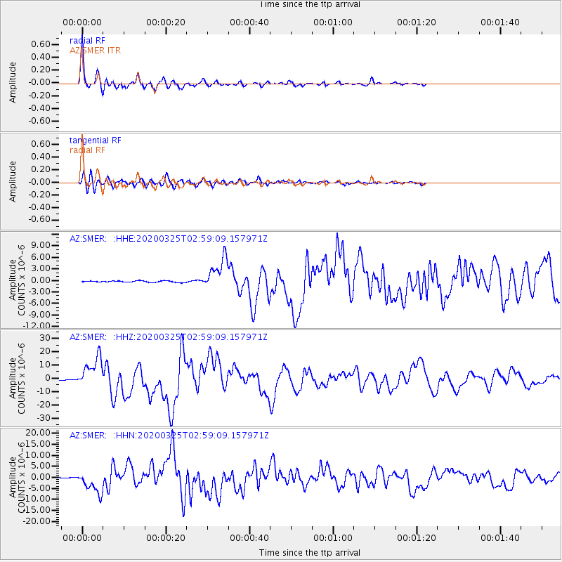
Signal To Noise
| Channel | StoN | STA | LTA |
| AZ:SMER: :HHZ:20200325T02:59:09.157971Z | 54.171577 | 1.1969882E-5 | 2.2096239E-7 |
| AZ:SMER: :HHN:20200325T02:59:09.157971Z | 14.92695 | 5.0622816E-6 | 3.3913705E-7 |
| AZ:SMER: :HHE:20200325T02:59:09.157971Z | 22.202412 | 4.1722296E-6 | 1.8791785E-7 |
| Arrivals |
| Ps | 3.8 SECOND |
| PpPs | 13 SECOND |
| PsPs/PpSs | 17 SECOND |


