You are here: Home > Network List > BC - Red Sismica del Noroeste de Mexico Stations List
> Station CCX CICESE CCX, , , MEXICO > Earthquake Result Viewer
CCX CICESE CCX, , , MEXICO - Earthquake Result Viewer
| Earthquake location: |
East Of Kuril Islands |
| Earthquake latitude/longitude: |
49.0/157.7 |
| Earthquake time(UTC): |
2020/03/25 (085) 02:49:21 GMT |
| Earthquake Depth: |
57 km |
| Earthquake Magnitude: |
7.5 Mww |
| Earthquake Catalog/Contributor: |
NEIC PDE/us |
|
| Network: |
BC Red Sismica del Noroeste de Mexico |
| Station: |
CCX CICESE CCX, , , MEXICO |
| Lat/Lon: |
31.87 N/116.66 W |
| Elevation: |
37 m |
|
| Distance: |
64.0 deg |
| Az: |
70.678 deg |
| Baz: |
313.062 deg |
| Ray Param: |
0.05905816 |
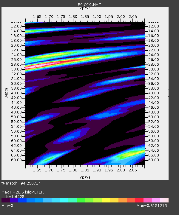
| Estimated Moho Depth: |
28.5 km |
| Estimated Crust Vp/Vs: |
1.64 |
| Assumed Crust Vp: |
6.183 km/s |
| Estimated Crust Vs: |
3.764 km/s |
| Estimated Crust Poisson's Ratio: |
0.21 |
|
| Radial Match: |
94.256714 % |
| Radial Bump: |
302 |
| Transverse Match: |
85.11526 % |
| Transverse Bump: |
400 |
| SOD ConfigId: |
20906531 |
| Insert Time: |
2020-04-08 14:50:50.932 +0000 |
| GWidth: |
2.5 |
| Max Bumps: |
400 |
| Tol: |
0.001 |
|

Signal To Noise
| Channel | StoN | STA | LTA |
| BC:CCX: :HHZ:20200325T02:59:18.325024Z | 35.91354 | 1.1716601E-5 | 3.2624465E-7 |
| BC:CCX: :HHN:20200325T02:59:18.325024Z | 9.279444 | 3.7435277E-6 | 4.0342155E-7 |
| BC:CCX: :HHE:20200325T02:59:18.325024Z | 17.051773 | 4.767447E-6 | 2.795866E-7 |
| Arrivals |
| Ps | 3.1 SECOND |
| PpPs | 12 SECOND |
| PsPs/PpSs | 15 SECOND |


