You are here: Home > Network List > CC - Cascade Chain Volcano Monitoring Stations List
> Station REM Rembrant, Mount St. Helens > Earthquake Result Viewer
REM Rembrant, Mount St. Helens - Earthquake Result Viewer
| Earthquake location: |
East Of Kuril Islands |
| Earthquake latitude/longitude: |
49.0/157.7 |
| Earthquake time(UTC): |
2020/03/25 (085) 02:49:21 GMT |
| Earthquake Depth: |
57 km |
| Earthquake Magnitude: |
7.5 Mww |
| Earthquake Catalog/Contributor: |
NEIC PDE/us |
|
| Network: |
CC Cascade Chain Volcano Monitoring |
| Station: |
REM Rembrant, Mount St. Helens |
| Lat/Lon: |
46.20 N/122.19 W |
| Elevation: |
1905 m |
|
| Distance: |
51.7 deg |
| Az: |
60.682 deg |
| Baz: |
304.213 deg |
| Ray Param: |
0.06709226 |
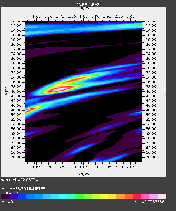
| Estimated Moho Depth: |
38.75 km |
| Estimated Crust Vp/Vs: |
1.75 |
| Assumed Crust Vp: |
6.566 km/s |
| Estimated Crust Vs: |
3.752 km/s |
| Estimated Crust Poisson's Ratio: |
0.26 |
|
| Radial Match: |
92.85374 % |
| Radial Bump: |
400 |
| Transverse Match: |
89.086525 % |
| Transverse Bump: |
400 |
| SOD ConfigId: |
20906531 |
| Insert Time: |
2020-04-08 14:52:41.205 +0000 |
| GWidth: |
2.5 |
| Max Bumps: |
400 |
| Tol: |
0.001 |
|

Signal To Noise
| Channel | StoN | STA | LTA |
| CC:REM: :BHZ:20200325T02:57:52.115002Z | 29.813663 | 1.2957633E-5 | 4.3462063E-7 |
| CC:REM: :BHN:20200325T02:57:52.115002Z | 7.493313 | 4.1592216E-6 | 5.550578E-7 |
| CC:REM: :BHE:20200325T02:57:52.115002Z | 6.7546415 | 4.930657E-6 | 7.2996573E-7 |
| Arrivals |
| Ps | 4.7 SECOND |
| PpPs | 15 SECOND |
| PsPs/PpSs | 20 SECOND |


