You are here: Home > Network List > CI - Caltech Regional Seismic Network Stations List
> Station CIA CIA, Avalon Catalina Island, CA, USA > Earthquake Result Viewer
CIA CIA, Avalon Catalina Island, CA, USA - Earthquake Result Viewer
| Earthquake location: |
East Of Kuril Islands |
| Earthquake latitude/longitude: |
49.0/157.7 |
| Earthquake time(UTC): |
2020/03/25 (085) 02:49:21 GMT |
| Earthquake Depth: |
57 km |
| Earthquake Magnitude: |
7.5 Mww |
| Earthquake Catalog/Contributor: |
NEIC PDE/us |
|
| Network: |
CI Caltech Regional Seismic Network |
| Station: |
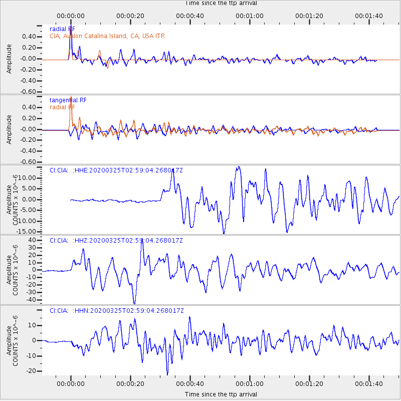
CIA CIA, Avalon Catalina Island, CA, USA |
| Lat/Lon: |
33.40 N/118.41 W |
| Elevation: |
467 m |
|
| Distance: |
61.9 deg |
| Az: |
70.534 deg |
| Baz: |
312.058 deg |
| Ray Param: |
0.06044649 |
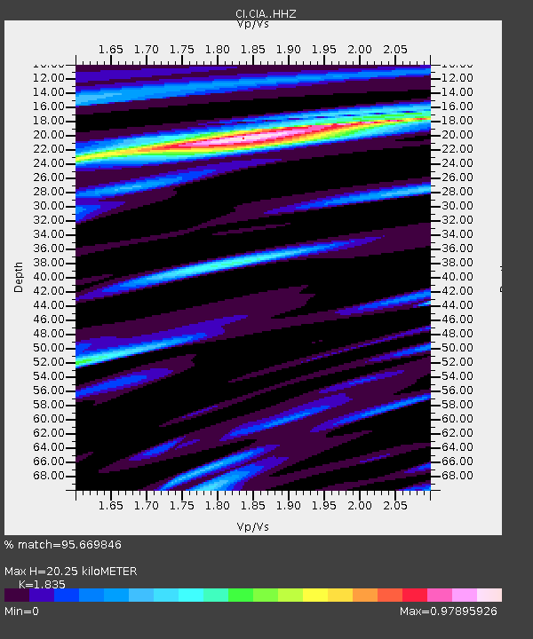
| Estimated Moho Depth: |
20.25 km |
| Estimated Crust Vp/Vs: |
1.84 |
| Assumed Crust Vp: |
6.048 km/s |
| Estimated Crust Vs: |
3.296 km/s |
| Estimated Crust Poisson's Ratio: |
0.29 |
|
| Radial Match: |
95.669846 % |
| Radial Bump: |
400 |
| Transverse Match: |
87.16516 % |
| Transverse Bump: |
400 |
| SOD ConfigId: |
20906531 |
| Insert Time: |
2020-04-08 14:53:28.672 +0000 |
| GWidth: |
2.5 |
| Max Bumps: |
400 |
| Tol: |
0.001 |
|
Signal To Noise
| Channel | StoN | STA | LTA |
| CI:CIA: :HHZ:20200325T02:59:04.268017Z | 31.17912 | 1.3479304E-5 | 4.323183E-7 |
| CI:CIA: :HHN:20200325T02:59:04.268017Z | 8.858242 | 4.121333E-6 | 4.65254E-7 |
| CI:CIA: :HHE:20200325T02:59:04.268017Z | 18.580282 | 6.7010296E-6 | 3.6065273E-7 |
| Arrivals |
| Ps | 2.9 SECOND |
| PpPs | 9.1 SECOND |
| PsPs/PpSs | 12 SECOND |


