You are here: Home > Network List > CI - Caltech Regional Seismic Network Stations List
> Station IKP In-Ko-Pah, Jacumba, CA, USA > Earthquake Result Viewer
IKP In-Ko-Pah, Jacumba, CA, USA - Earthquake Result Viewer
| Earthquake location: |
East Of Kuril Islands |
| Earthquake latitude/longitude: |
49.0/157.7 |
| Earthquake time(UTC): |
2020/03/25 (085) 02:49:21 GMT |
| Earthquake Depth: |
57 km |
| Earthquake Magnitude: |
7.5 Mww |
| Earthquake Catalog/Contributor: |
NEIC PDE/us |
|
| Network: |
CI Caltech Regional Seismic Network |
| Station: |
IKP In-Ko-Pah, Jacumba, CA, USA |
| Lat/Lon: |
32.65 N/116.11 W |
| Elevation: |
906 m |
|
| Distance: |
63.8 deg |
| Az: |
69.686 deg |
| Baz: |
312.921 deg |
| Ray Param: |
0.05918542 |
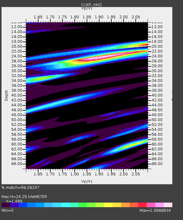
| Estimated Moho Depth: |
24.25 km |
| Estimated Crust Vp/Vs: |
1.89 |
| Assumed Crust Vp: |
6.264 km/s |
| Estimated Crust Vs: |
3.305 km/s |
| Estimated Crust Poisson's Ratio: |
0.31 |
|
| Radial Match: |
96.06247 % |
| Radial Bump: |
400 |
| Transverse Match: |
85.04268 % |
| Transverse Bump: |
400 |
| SOD ConfigId: |
20906531 |
| Insert Time: |
2020-04-08 14:53:58.210 +0000 |
| GWidth: |
2.5 |
| Max Bumps: |
400 |
| Tol: |
0.001 |
|

Signal To Noise
| Channel | StoN | STA | LTA |
| CI:IKP: :HHZ:20200325T02:59:17.088024Z | 39.703487 | 1.06931375E-5 | 2.6932491E-7 |
| CI:IKP: :HHN:20200325T02:59:17.088024Z | 17.671486 | 4.07356E-6 | 2.30516E-7 |
| CI:IKP: :HHE:20200325T02:59:17.088024Z | 13.523379 | 3.4964346E-6 | 2.585474E-7 |
| Arrivals |
| Ps | 3.6 SECOND |
| PpPs | 11 SECOND |
| PsPs/PpSs | 14 SECOND |


