You are here: Home > Network List > CI - Caltech Regional Seismic Network Stations List
> Station OSI Osito Adit, California, USA > Earthquake Result Viewer
OSI Osito Adit, California, USA - Earthquake Result Viewer

| Earthquake location: |
East Of Kuril Islands |
| Earthquake latitude/longitude: |
49.0/157.7 |
| Earthquake time(UTC): |
2020/03/25 (085) 02:49:21 GMT |
| Earthquake Depth: |
57 km |
| Earthquake Magnitude: |
7.5 Mww |
| Earthquake Catalog/Contributor: |
NEIC PDE/us |
|
| Network: |
CI Caltech Regional Seismic Network |
| Station: |
OSI Osito Adit, California, USA |
| Lat/Lon: |
34.61 N/118.72 W |
| Elevation: |
706 m |
|
| Distance: |
60.9 deg |
| Az: |
69.702 deg |
| Baz: |
311.487 deg |
| Ray Param: |
0.061091524 |
| Estimated Moho Depth: |
17.75 km |
| Estimated Crust Vp/Vs: |
2.10 |
| Assumed Crust Vp: |
6.1 km/s |
| Estimated Crust Vs: |
2.908 km/s |
| Estimated Crust Poisson's Ratio: |
0.35 |
|
| Radial Match: |
95.02406 % |
| Radial Bump: |
400 |
| Transverse Match: |
87.63578 % |
| Transverse Bump: |
400 |
| SOD ConfigId: |
20906531 |
| Insert Time: |
2020-04-08 14:54:18.719 +0000 |
| GWidth: |
2.5 |
| Max Bumps: |
400 |
| Tol: |
0.001 |
|
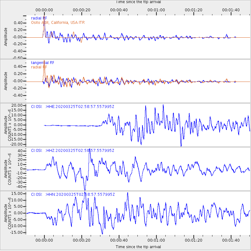
Signal To Noise
| Channel | StoN | STA | LTA |
| CI:OSI: :HHZ:20200325T02:58:57.557995Z | 32.72903 | 1.272745E-5 | 3.888734E-7 |
| CI:OSI: :HHN:20200325T02:58:57.557995Z | 12.776684 | 3.5164446E-6 | 2.7522358E-7 |
| CI:OSI: :HHE:20200325T02:58:57.557995Z | 22.038948 | 4.668596E-6 | 2.1183388E-7 |
| Arrivals |
| Ps | 3.3 SECOND |
| PpPs | 8.7 SECOND |
| PsPs/PpSs | 12 SECOND |


