You are here: Home > Network List > CI - Caltech Regional Seismic Network Stations List
> Station TUQ Turquiose Mountain, Baker, CA, USA > Earthquake Result Viewer
TUQ Turquiose Mountain, Baker, CA, USA - Earthquake Result Viewer
| Earthquake location: |
East Of Kuril Islands |
| Earthquake latitude/longitude: |
49.0/157.7 |
| Earthquake time(UTC): |
2020/03/25 (085) 02:49:21 GMT |
| Earthquake Depth: |
57 km |
| Earthquake Magnitude: |
7.5 Mww |
| Earthquake Catalog/Contributor: |
NEIC PDE/us |
|
| Network: |
CI Caltech Regional Seismic Network |
| Station: |
TUQ Turquiose Mountain, Baker, CA, USA |
| Lat/Lon: |
35.44 N/115.92 W |
| Elevation: |
1350 m |
|
| Distance: |
62.1 deg |
| Az: |
67.266 deg |
| Baz: |
311.925 deg |
| Ray Param: |
0.06033235 |
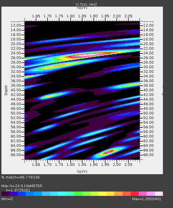
| Estimated Moho Depth: |
24.5 km |
| Estimated Crust Vp/Vs: |
1.87 |
| Assumed Crust Vp: |
6.276 km/s |
| Estimated Crust Vs: |
3.352 km/s |
| Estimated Crust Poisson's Ratio: |
0.30 |
|
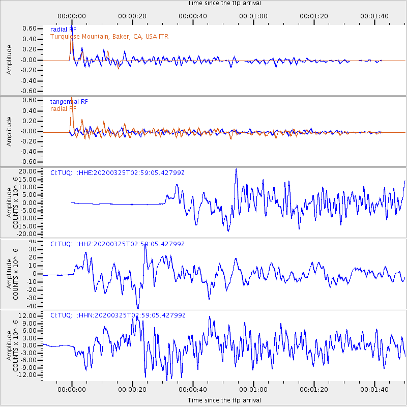
| Radial Match: |
96.778336 % |
| Radial Bump: |
400 |
| Transverse Match: |
88.54098 % |
| Transverse Bump: |
400 |
| SOD ConfigId: |
20906531 |
| Insert Time: |
2020-04-08 14:54:54.324 +0000 |
| GWidth: |
2.5 |
| Max Bumps: |
400 |
| Tol: |
0.001 |
|
Signal To Noise
| Channel | StoN | STA | LTA |
| CI:TUQ: :HHZ:20200325T02:59:05.42799Z | 59.62874 | 1.2262025E-5 | 2.0563951E-7 |
| CI:TUQ: :HHN:20200325T02:59:05.42799Z | 12.58251 | 3.874984E-6 | 3.079659E-7 |
| CI:TUQ: :HHE:20200325T02:59:05.42799Z | 19.591516 | 5.0550743E-6 | 2.5802365E-7 |
| Arrivals |
| Ps | 3.5 SECOND |
| PpPs | 11 SECOND |
| PsPs/PpSs | 14 SECOND |


