You are here: Home > Network List > CN - Canadian National Seismograph Network Stations List
> Station BLKN Baker Lake, NU, CA > Earthquake Result Viewer
BLKN Baker Lake, NU, CA - Earthquake Result Viewer
| Earthquake location: |
East Of Kuril Islands |
| Earthquake latitude/longitude: |
49.0/157.7 |
| Earthquake time(UTC): |
2020/03/25 (085) 02:49:21 GMT |
| Earthquake Depth: |
57 km |
| Earthquake Magnitude: |
7.5 Mww |
| Earthquake Catalog/Contributor: |
NEIC PDE/us |
|
| Network: |
CN Canadian National Seismograph Network |
| Station: |
BLKN Baker Lake, NU, CA |
| Lat/Lon: |
64.32 N/96.00 W |
| Elevation: |
40 m |
|
| Distance: |
53.4 deg |
| Az: |
31.407 deg |
| Baz: |
308.018 deg |
| Ray Param: |
0.06600315 |
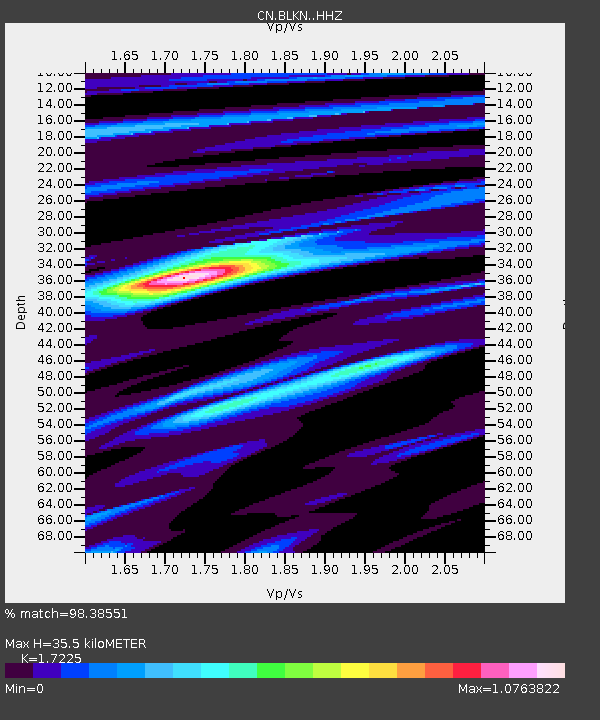
| Estimated Moho Depth: |
35.5 km |
| Estimated Crust Vp/Vs: |
1.72 |
| Assumed Crust Vp: |
6.459 km/s |
| Estimated Crust Vs: |
3.75 km/s |
| Estimated Crust Poisson's Ratio: |
0.25 |
|
| Radial Match: |
98.38551 % |
| Radial Bump: |
268 |
| Transverse Match: |
92.26796 % |
| Transverse Bump: |
400 |
| SOD ConfigId: |
20906531 |
| Insert Time: |
2020-04-08 14:55:21.274 +0000 |
| GWidth: |
2.5 |
| Max Bumps: |
400 |
| Tol: |
0.001 |
|

Signal To Noise
| Channel | StoN | STA | LTA |
| CN:BLKN: :HHZ:20200325T02:58:04.459973Z | 47.871063 | 1.7479248E-5 | 3.651318E-7 |
| CN:BLKN: :HHN:20200325T02:58:04.459973Z | 25.38148 | 6.8423187E-6 | 2.695792E-7 |
| CN:BLKN: :HHE:20200325T02:58:04.459973Z | 28.276329 | 6.6225607E-6 | 2.3420864E-7 |
| Arrivals |
| Ps | 4.2 SECOND |
| PpPs | 14 SECOND |
| PsPs/PpSs | 18 SECOND |


