You are here: Home > Network List > CN - Canadian National Seismograph Network Stations List
> Station CLRS Cowichan Lake Research St, BC, CA > Earthquake Result Viewer
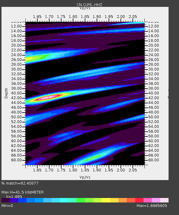
CLRS Cowichan Lake Research St, BC, CA - Earthquake Result Viewer
| Earthquake location: |
East Of Kuril Islands |
| Earthquake latitude/longitude: |
49.0/157.7 |
| Earthquake time(UTC): |
2020/03/25 (085) 02:49:21 GMT |
| Earthquake Depth: |
57 km |
| Earthquake Magnitude: |
7.5 Mww |
| Earthquake Catalog/Contributor: |
NEIC PDE/us |
|
| Network: |
CN Canadian National Seismograph Network |
| Station: |
CLRS Cowichan Lake Research St, BC, CA |
| Lat/Lon: |
48.82 N/124.13 W |
| Elevation: |
174 m |
|
| Distance: |
49.2 deg |
| Az: |
58.756 deg |
| Baz: |
301.555 deg |
| Ray Param: |
0.06873608 |
| Estimated Moho Depth: |
41.5 km |
| Estimated Crust Vp/Vs: |
1.70 |
| Assumed Crust Vp: |
6.391 km/s |
| Estimated Crust Vs: |
3.77 km/s |
| Estimated Crust Poisson's Ratio: |
0.23 |
|
| Radial Match: |
92.40877 % |
| Radial Bump: |
400 |
| Transverse Match: |
85.558266 % |
| Transverse Bump: |
400 |
| SOD ConfigId: |
20906531 |
| Insert Time: |
2020-04-08 14:55:36.175 +0000 |
| GWidth: |
2.5 |
| Max Bumps: |
400 |
| Tol: |
0.001 |
|

Signal To Noise
| Channel | StoN | STA | LTA |
| CN:CLRS: :HHZ:20200325T02:57:33.060009Z | 30.998558 | 1.2249622E-5 | 3.9516746E-7 |
| CN:CLRS: :HHN:20200325T02:57:33.060009Z | 20.37036 | 3.0018766E-6 | 1.4736493E-7 |
| CN:CLRS: :HHE:20200325T02:57:33.060009Z | 21.336126 | 5.9906115E-6 | 2.8077318E-7 |
| Arrivals |
| Ps | 4.8 SECOND |
| PpPs | 16 SECOND |
| PsPs/PpSs | 21 SECOND |


