You are here: Home > Network List > CN - Canadian National Seismograph Network Stations List
> Station DRLN Deer Lake, NFLD. > Earthquake Result Viewer
DRLN Deer Lake, NFLD. - Earthquake Result Viewer
| Earthquake location: |
East Of Kuril Islands |
| Earthquake latitude/longitude: |
49.0/157.7 |
| Earthquake time(UTC): |
2020/03/25 (085) 02:49:21 GMT |
| Earthquake Depth: |
57 km |
| Earthquake Magnitude: |
7.5 Mww |
| Earthquake Catalog/Contributor: |
NEIC PDE/us |
|
| Network: |
CN Canadian National Seismograph Network |
| Station: |
DRLN Deer Lake, NFLD. |
| Lat/Lon: |
49.26 N/57.50 W |
| Elevation: |
238 m |
|
| Distance: |
77.5 deg |
| Az: |
22.753 deg |
| Baz: |
337.117 deg |
| Ray Param: |
0.050151568 |
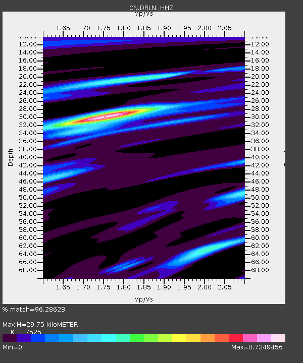
| Estimated Moho Depth: |
29.75 km |
| Estimated Crust Vp/Vs: |
1.75 |
| Assumed Crust Vp: |
6.35 km/s |
| Estimated Crust Vs: |
3.623 km/s |
| Estimated Crust Poisson's Ratio: |
0.26 |
|
| Radial Match: |
96.28628 % |
| Radial Bump: |
292 |
| Transverse Match: |
90.00543 % |
| Transverse Bump: |
400 |
| SOD ConfigId: |
20906531 |
| Insert Time: |
2020-04-08 14:55:43.293 +0000 |
| GWidth: |
2.5 |
| Max Bumps: |
400 |
| Tol: |
0.001 |
|

Signal To Noise
| Channel | StoN | STA | LTA |
| CN:DRLN: :HHZ:20200325T03:00:40.120007Z | 19.914236 | 1.1997375E-5 | 6.0245213E-7 |
| CN:DRLN: :HHN:20200325T03:00:40.120007Z | 8.070826 | 4.5746483E-6 | 5.6681296E-7 |
| CN:DRLN: :HHE:20200325T03:00:40.120007Z | 3.3294694 | 1.7573167E-6 | 5.278068E-7 |
| Arrivals |
| Ps | 3.6 SECOND |
| PpPs | 13 SECOND |
| PsPs/PpSs | 16 SECOND |


