You are here: Home > Network List > CN - Canadian National Seismograph Network Stations List
> Station MYRA Myra Falls, BC, CA > Earthquake Result Viewer
MYRA Myra Falls, BC, CA - Earthquake Result Viewer
| Earthquake location: |
East Of Kuril Islands |
| Earthquake latitude/longitude: |
49.0/157.7 |
| Earthquake time(UTC): |
2020/03/25 (085) 02:49:21 GMT |
| Earthquake Depth: |
57 km |
| Earthquake Magnitude: |
7.5 Mww |
| Earthquake Catalog/Contributor: |
NEIC PDE/us |
|
| Network: |
CN Canadian National Seismograph Network |
| Station: |
MYRA Myra Falls, BC, CA |
| Lat/Lon: |
49.55 N/125.57 W |
| Elevation: |
632 m |
|
| Distance: |
48.0 deg |
| Az: |
58.567 deg |
| Baz: |
300.343 deg |
| Ray Param: |
0.06950445 |
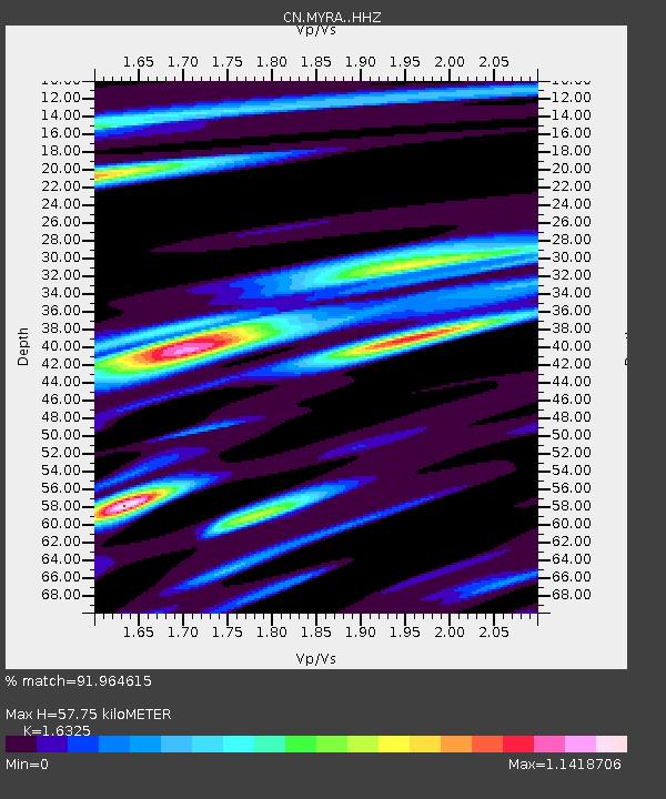
| Estimated Moho Depth: |
57.75 km |
| Estimated Crust Vp/Vs: |
1.63 |
| Assumed Crust Vp: |
6.391 km/s |
| Estimated Crust Vs: |
3.915 km/s |
| Estimated Crust Poisson's Ratio: |
0.20 |
|
| Radial Match: |
91.964615 % |
| Radial Bump: |
373 |
| Transverse Match: |
84.0278 % |
| Transverse Bump: |
400 |
| SOD ConfigId: |
20906531 |
| Insert Time: |
2020-04-08 14:56:39.567 +0000 |
| GWidth: |
2.5 |
| Max Bumps: |
400 |
| Tol: |
0.001 |
|

Signal To Noise
| Channel | StoN | STA | LTA |
| CN:MYRA: :HHZ:20200325T02:57:23.960003Z | 25.811699 | 1.12615835E-5 | 4.3629763E-7 |
| CN:MYRA: :HHN:20200325T02:57:23.960003Z | 10.560946 | 2.8973402E-6 | 2.7434473E-7 |
| CN:MYRA: :HHE:20200325T02:57:23.960003Z | 15.695546 | 6.1301644E-6 | 3.9056712E-7 |
| Arrivals |
| Ps | 6.1 SECOND |
| PpPs | 22 SECOND |
| PsPs/PpSs | 28 SECOND |


