You are here: Home > Network List > CN - Canadian National Seismograph Network Stations List
> Station RES Resolute, NU, CA > Earthquake Result Viewer
RES Resolute, NU, CA - Earthquake Result Viewer
| Earthquake location: |
East Of Kuril Islands |
| Earthquake latitude/longitude: |
49.0/157.7 |
| Earthquake time(UTC): |
2020/03/25 (085) 02:49:21 GMT |
| Earthquake Depth: |
57 km |
| Earthquake Magnitude: |
7.5 Mww |
| Earthquake Catalog/Contributor: |
NEIC PDE/us |
|
| Network: |
CN Canadian National Seismograph Network |
| Station: |
RES Resolute, NU, CA |
| Lat/Lon: |
74.69 N/94.90 W |
| Elevation: |
19 m |
|
| Distance: |
47.7 deg |
| Az: |
20.045 deg |
| Baz: |
301.814 deg |
| Ray Param: |
0.06968521 |
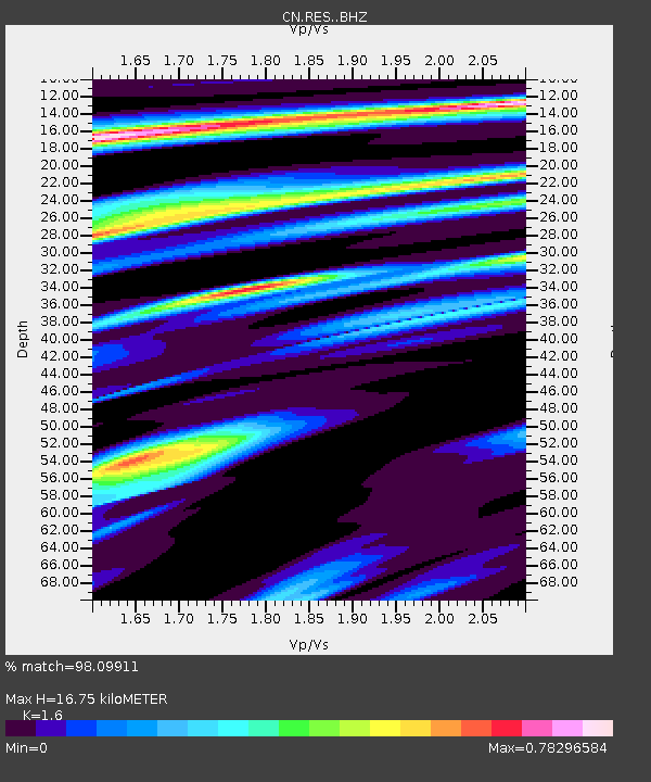
| Estimated Moho Depth: |
16.75 km |
| Estimated Crust Vp/Vs: |
1.60 |
| Assumed Crust Vp: |
6.367 km/s |
| Estimated Crust Vs: |
3.979 km/s |
| Estimated Crust Poisson's Ratio: |
0.18 |
|
| Radial Match: |
98.09911 % |
| Radial Bump: |
251 |
| Transverse Match: |
90.646126 % |
| Transverse Bump: |
400 |
| SOD ConfigId: |
20906531 |
| Insert Time: |
2020-04-08 14:57:17.473 +0000 |
| GWidth: |
2.5 |
| Max Bumps: |
400 |
| Tol: |
0.001 |
|
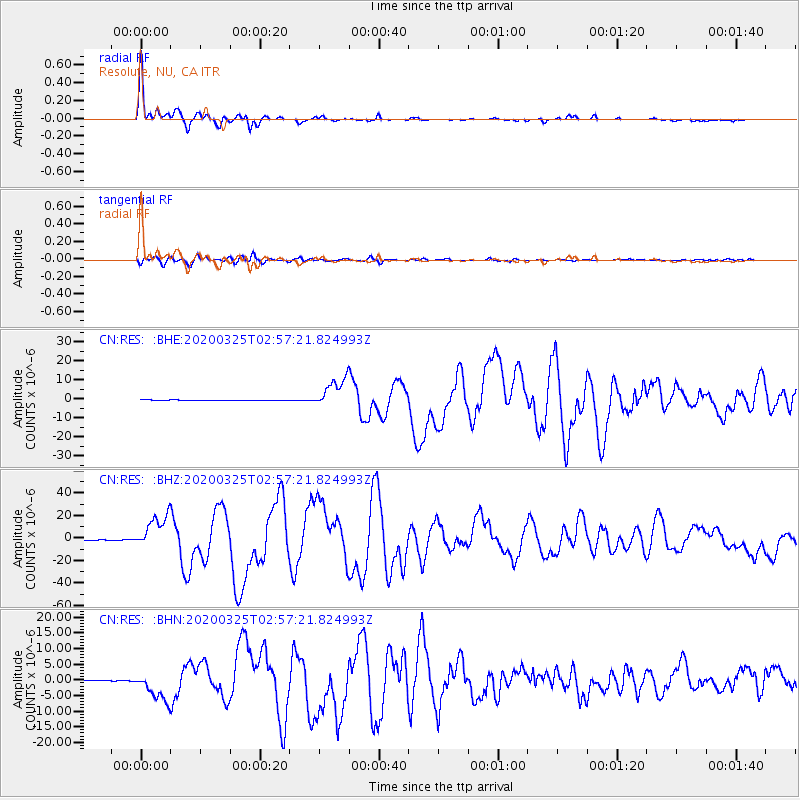
Signal To Noise
| Channel | StoN | STA | LTA |
| CN:RES: :BHZ:20200325T02:57:21.824993Z | 38.579296 | 1.5050098E-5 | 3.9010814E-7 |
| CN:RES: :BHN:20200325T02:57:21.824993Z | 25.456102 | 4.5498996E-6 | 1.7873512E-7 |
| CN:RES: :BHE:20200325T02:57:21.824993Z | 41.020847 | 7.892957E-6 | 1.9241331E-7 |
| Arrivals |
| Ps | 1.7 SECOND |
| PpPs | 6.4 SECOND |
| PsPs/PpSs | 8.1 SECOND |


