You are here: Home > Network List > CN - Canadian National Seismograph Network Stations List
> Station SYMB Survey Mountain, BC, CA > Earthquake Result Viewer
SYMB Survey Mountain, BC, CA - Earthquake Result Viewer
| Earthquake location: |
East Of Kuril Islands |
| Earthquake latitude/longitude: |
49.0/157.7 |
| Earthquake time(UTC): |
2020/03/25 (085) 02:49:21 GMT |
| Earthquake Depth: |
57 km |
| Earthquake Magnitude: |
7.5 Mww |
| Earthquake Catalog/Contributor: |
NEIC PDE/us |
|
| Network: |
CN Canadian National Seismograph Network |
| Station: |
SYMB Survey Mountain, BC, CA |
| Lat/Lon: |
48.56 N/123.80 W |
| Elevation: |
945 m |
|
| Distance: |
49.5 deg |
| Az: |
58.896 deg |
| Baz: |
301.895 deg |
| Ray Param: |
0.06852922 |
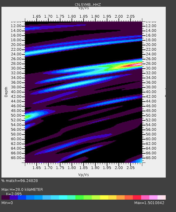
| Estimated Moho Depth: |
28.0 km |
| Estimated Crust Vp/Vs: |
2.10 |
| Assumed Crust Vp: |
6.566 km/s |
| Estimated Crust Vs: |
3.134 km/s |
| Estimated Crust Poisson's Ratio: |
0.35 |
|
| Radial Match: |
96.24828 % |
| Radial Bump: |
357 |
| Transverse Match: |
84.6714 % |
| Transverse Bump: |
400 |
| SOD ConfigId: |
20906531 |
| Insert Time: |
2020-04-08 14:57:33.992 +0000 |
| GWidth: |
2.5 |
| Max Bumps: |
400 |
| Tol: |
0.001 |
|

Signal To Noise
| Channel | StoN | STA | LTA |
| CN:SYMB: :HHZ:20200325T02:57:35.53001Z | 43.24868 | 1.2449811E-5 | 2.8786567E-7 |
| CN:SYMB: :HHN:20200325T02:57:35.53001Z | 13.1526165 | 3.0645824E-6 | 2.3300174E-7 |
| CN:SYMB: :HHE:20200325T02:57:35.53001Z | 21.357214 | 6.4854444E-6 | 3.0366527E-7 |
| Arrivals |
| Ps | 4.9 SECOND |
| PpPs | 13 SECOND |
| PsPs/PpSs | 17 SECOND |


