You are here: Home > Network List > CO - South Carolina Seismic Network Stations List
> Station CASEE Lake Jocassee, SC, USA > Earthquake Result Viewer
CASEE Lake Jocassee, SC, USA - Earthquake Result Viewer
| Earthquake location: |
East Of Kuril Islands |
| Earthquake latitude/longitude: |
49.0/157.7 |
| Earthquake time(UTC): |
2020/03/25 (085) 02:49:21 GMT |
| Earthquake Depth: |
57 km |
| Earthquake Magnitude: |
7.5 Mww |
| Earthquake Catalog/Contributor: |
NEIC PDE/us |
|
| Network: |
CO South Carolina Seismic Network |
| Station: |
CASEE Lake Jocassee, SC, USA |
| Lat/Lon: |
34.99 N/82.93 W |
| Elevation: |
385 m |
|
| Distance: |
80.5 deg |
| Az: |
46.495 deg |
| Baz: |
324.412 deg |
| Ray Param: |
0.048099183 |
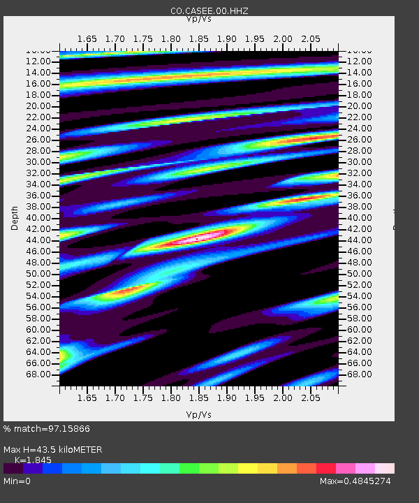
| Estimated Moho Depth: |
43.5 km |
| Estimated Crust Vp/Vs: |
1.85 |
| Assumed Crust Vp: |
6.35 km/s |
| Estimated Crust Vs: |
3.442 km/s |
| Estimated Crust Poisson's Ratio: |
0.29 |
|
| Radial Match: |
97.15866 % |
| Radial Bump: |
276 |
| Transverse Match: |
90.527 % |
| Transverse Bump: |
400 |
| SOD ConfigId: |
20906531 |
| Insert Time: |
2020-04-08 14:58:03.345 +0000 |
| GWidth: |
2.5 |
| Max Bumps: |
400 |
| Tol: |
0.001 |
|

Signal To Noise
| Channel | StoN | STA | LTA |
| CO:CASEE:00:HHZ:20200325T03:00:56.468029Z | 42.987057 | 1.3108177E-5 | 3.0493314E-7 |
| CO:CASEE:00:HHN:20200325T03:00:56.468029Z | 29.843107 | 3.947185E-6 | 1.3226455E-7 |
| CO:CASEE:00:HHE:20200325T03:00:56.468029Z | 14.700812 | 2.7839799E-6 | 1.8937592E-7 |
| Arrivals |
| Ps | 5.9 SECOND |
| PpPs | 19 SECOND |
| PsPs/PpSs | 25 SECOND |


