You are here: Home > Network List > CO - South Carolina Seismic Network Stations List
> Station SUMMV Summerville Airport, SC, USA > Earthquake Result Viewer
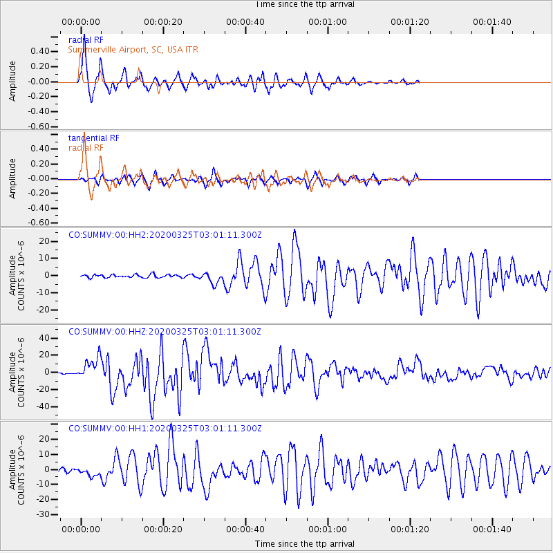
SUMMV Summerville Airport, SC, USA - Earthquake Result Viewer
| Earthquake location: |
East Of Kuril Islands |
| Earthquake latitude/longitude: |
49.0/157.7 |
| Earthquake time(UTC): |
2020/03/25 (085) 02:49:21 GMT |
| Earthquake Depth: |
57 km |
| Earthquake Magnitude: |
7.5 Mww |
| Earthquake Catalog/Contributor: |
NEIC PDE/us |
|
| Network: |
CO South Carolina Seismic Network |
| Station: |
SUMMV Summerville Airport, SC, USA |
| Lat/Lon: |
33.07 N/80.27 W |
| Elevation: |
17 m |
|
| Distance: |
83.4 deg |
| Az: |
45.777 deg |
| Baz: |
325.793 deg |
| Ray Param: |
0.04612388 |
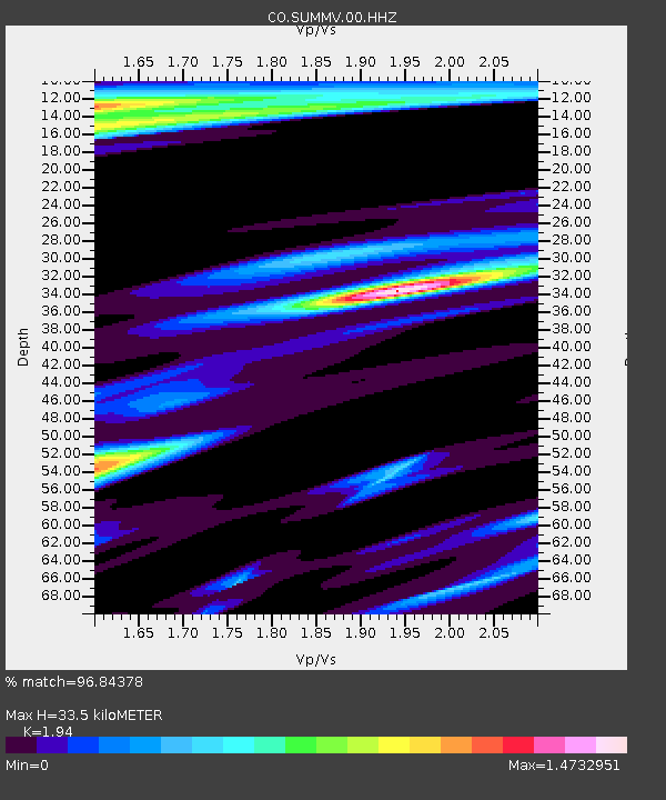
| Estimated Moho Depth: |
33.5 km |
| Estimated Crust Vp/Vs: |
1.94 |
| Assumed Crust Vp: |
6.565 km/s |
| Estimated Crust Vs: |
3.384 km/s |
| Estimated Crust Poisson's Ratio: |
0.32 |
|
| Radial Match: |
96.84378 % |
| Radial Bump: |
376 |
| Transverse Match: |
89.54682 % |
| Transverse Bump: |
380 |
| SOD ConfigId: |
20906531 |
| Insert Time: |
2020-04-08 14:58:11.860 +0000 |
| GWidth: |
2.5 |
| Max Bumps: |
400 |
| Tol: |
0.001 |
|
Signal To Noise
| Channel | StoN | STA | LTA |
| CO:SUMMV:00:HHZ:20200325T03:01:11.300Z | 18.705853 | 1.3461352E-5 | 7.1963314E-7 |
| CO:SUMMV:00:HH1:20200325T03:01:11.300Z | 2.4148314 | 2.7606895E-6 | 1.1432224E-6 |
| CO:SUMMV:00:HH2:20200325T03:01:11.300Z | 3.944215 | 3.3763577E-6 | 8.560278E-7 |
| Arrivals |
| Ps | 4.9 SECOND |
| PpPs | 15 SECOND |
| PsPs/PpSs | 20 SECOND |


