You are here: Home > Network List > CZ - Czech Regional Seismic Network Stations List
> Station KHC CZ.KHC > Earthquake Result Viewer
KHC CZ.KHC - Earthquake Result Viewer

| Earthquake location: |
East Of Kuril Islands |
| Earthquake latitude/longitude: |
49.0/157.7 |
| Earthquake time(UTC): |
2020/03/25 (085) 02:49:21 GMT |
| Earthquake Depth: |
57 km |
| Earthquake Magnitude: |
7.5 Mww |
| Earthquake Catalog/Contributor: |
NEIC PDE/us |
|
| Network: |
CZ Czech Regional Seismic Network |
| Station: |
KHC CZ.KHC |
| Lat/Lon: |
49.13 N/13.58 E |
| Elevation: |
700 m |
|
| Distance: |
77.5 deg |
| Az: |
336.772 deg |
| Baz: |
23.299 deg |
| Ray Param: |
0.05019286 |
| Estimated Moho Depth: |
38.75 km |
| Estimated Crust Vp/Vs: |
1.69 |
| Assumed Crust Vp: |
6.276 km/s |
| Estimated Crust Vs: |
3.708 km/s |
| Estimated Crust Poisson's Ratio: |
0.23 |
|
| Radial Match: |
97.186615 % |
| Radial Bump: |
329 |
| Transverse Match: |
77.352295 % |
| Transverse Bump: |
400 |
| SOD ConfigId: |
20906531 |
| Insert Time: |
2020-04-08 14:58:32.896 +0000 |
| GWidth: |
2.5 |
| Max Bumps: |
400 |
| Tol: |
0.001 |
|
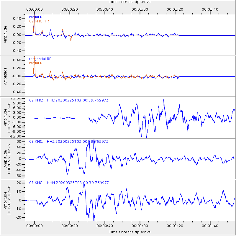
Signal To Noise
| Channel | StoN | STA | LTA |
| CZ:KHC: :HHZ:20200325T03:00:39.76997Z | 19.76362 | 6.2223735E-6 | 3.1483972E-7 |
| CZ:KHC: :HHN:20200325T03:00:39.76997Z | 10.627987 | 2.3016892E-6 | 2.165687E-7 |
| CZ:KHC: :HHE:20200325T03:00:39.76997Z | 5.7721047 | 1.156686E-6 | 2.0039242E-7 |
| Arrivals |
| Ps | 4.4 SECOND |
| PpPs | 16 SECOND |
| PsPs/PpSs | 21 SECOND |


